Greece kayaking tours are hosted paddling trips along the coasts and rivers of Greece. The page starts with the sea kayak and its roots in Alaska, Canada and Greenland. Next come Cape Caphereus on Euboea and three western rivers: the Louros, Thyamis and Neda. Four short answers on the word kayak, sea caves, coves and the Blue Cave of Kastellorizo close it. Trips on the water also appear under Greece sailing tours and Milos tours. Protected nature has its own page on national parks in Greece. Every other outing is listed under Greece tours.
Bookings made through the GetYourGuide widgets on this page earn Classical Greece Tours a commission, at no extra cost to the traveller.
What are Greece kayaking tours?
Greece kayaking tours are hosted trips along Greek shores in kayaks. Inuit hunters created this swift ocean craft for catching seals and walrus. Walruses are large tusked sea mammals. The Greek islands are well known for sea caves of great variety and beauty.
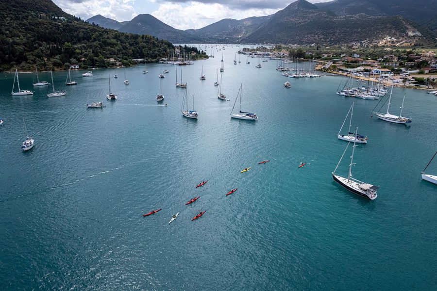
A sea kayak, or touring kayak, is made for open water, whether on lakes, bays or oceans. A kayak is a small, narrow boat moved by its paddler’s own strength. Sea kayaks give up the quick turning of whitewater kayaks for faster cruising and more cargo room. Whitewater means fast, foaming rapids on a river.
The craft behind Greece kayaking tours grew from native boats built in Alaska, northern Canada and Southwest Greenland. Iqyak was the ancient Aleut name for this kind of boat. Its earliest frames were light wood, tied together with sinew or baleen. Sinew is tough animal tendon; baleen is the bristly plate inside certain whales’ mouths.
The phrase sea kayaking is thought to have spread through a 1981 book by John Dowd. Before that book, people spoke of kayak touring, sea canoeing or coastal paddling. Blue-water paddling and canoe touring were two more of the older names. Blue water here means the open sea, far out from the shore.
- Coverings: The first Aleutian kayaks wore skins taken from sea lions or seals.
- Age: Archaeological finds date the boat type behind Greece kayaking tours to at least 4000 years ago.
- Fibreglass: Until fibreglass boats came in during the 1950s, wooden and fabric kayaks ruled the market.
The first rotomoulded plastic kayaks came out in 1984. Rotomoulding shapes hot plastic in a spinning mould. A sea kayak can carry one to three paddlers, plus camping gear and food. In British English, the craft of Greece kayaking tours also counts as a kind of canoe.
What past does Cape Caphereus bring to Greece kayaking tours?
Greece kayaking tours run through a country whose island of Euboea ends in Cape Caphereus to the southeast. A cape is a high point of land jutting into the sea. In earlier times, its channel was among the worst shipping dangers in the Aegean.
For Greece kayaking tours, the cape goes by three names: Caphereus, Kafireas and Cavo D’Oro. The last of these comes from the Italian words for Cape of Gold. Between the cape and nearby Andros lie the Kafireas Straits, also called the Doro Channel. A strait is a narrow passage of sea between two pieces of land.
For Greece kayaking tours, the channel’s past also holds the Battle of Doro Passage, a small naval clash. It took place on 16 October 1827. Greek pirates seized a British merchant ship in that fight. An escorting warship then set the captured vessel free. Pirates are sea raiders who attack and rob ships.
In myth, Nauplius ruled Euboea as king, and his son was Palamedes. Palamedes took part in the Trojan War but died at the hands of fellow Greeks. Nauplius then set out to punish King Agamemnon and the rest of the Greek leaders. A storm caught Agamemnon’s ships off Cape Caphereus on their voyage home from Troy.
- Ajax the Lesser: In the myth, Ajax the Lesser lost his life in that same storm.
- Sinkings: Channel losses include a British sailing ship in 1835 and an Italian tanker torpedoed in World War II.
- Kafireas: Besides the cape, the name Kafireas also belongs to a local community.
In the tale, Nauplius lit beacon fires on the rocks of the cape. The Greek sailors steered for the flames, taking them for a safe harbour. For Greece kayaking tours, the spot’s later name, Xylophagos, means Eater of Timber.
How does the Louros river fit into Greece kayaking tours?
Greece kayaking tours belong to a country whose northwestern Epirus region holds the Louros river. The river measures 80 kilometres from end to end. Its drainage area, meaning all the land whose rain and streams run into it, spans 963 square kilometres.
A large spring, a short way north of Vouliasta village, gives the Louros its start. That spring lies in the Ioannina regional unit. Greek regions split into smaller districts, and each one is called a regional unit. From there the river heads south through a canyon, which is a deep, narrow valley walled by cliffs.
Further down, the river reaches a dam, and after it a hydroelectric power station. Hydroelectric power is electricity drawn from flowing water. The Louros then flows by the town of Filippiada, on its way south. For Greece kayaking tours, the Louros also marks a border, splitting the Arta and Preveza regional units.
For Greece kayaking tours, the Louros is one of just two known homes of the Greek lamprey. The other is the Strymon River. This lamprey is a jawless fish, endemic to Greece. Endemic means native to one place and found nowhere else. It lives naturally in rivers and in freshwater springs.
- Mouth: The river ends in the marshes along the Ambracian Gulf’s northern shore.
- Name: The municipality of Louros, which the river flows through, is named after it.
- Threat: Habitat loss, the shrinking of the places where it lives, threatens the Greek lamprey.
For Greece kayaking tours, the Greek lamprey is also the lamprey species in gravest danger. It also goes by the name Macedonia brook lamprey. Scientists first grouped it with one set of lampreys, then moved it to another, called Caspiomyzon.
Why is the Thyamis a name to know on Greece kayaking tours?
Greece kayaking tours share their country with the Thyamis, which crosses Epirus to the Ionian Sea. The river is 115 kilometres long from source to mouth. It also goes by the names Glykys and Kalamas. In Greek, glykys means sweet.
Over 99 percent of its basin, which spans about 1,800 square kilometres, lies on Greek soil. In this sense, a basin means the whole area draining into one river. The ancient writer Pausanias named the Thyamis as the border between Thesprotis and Kestrine. The Suda, a Byzantine encyclopaedia, and the geographer Ptolemaeus also mention it.
For Greece kayaking tours, the Thyamis rises close to Kalpaki, a village in northwestern Ioannina. It flows south at first, then swings southwest near Soulopoulo. Near Vrosina it takes in the Tyria, one of its tributaries. Tributaries are side streams that add their water to a bigger river.
Its mouth opens onto the Ionian Sea by Kestrini, a village lying between Igoumenitsa and Sagiada. There the Thyamis spreads into a delta, north of Igoumenitsa. A delta is a fan of silt and small channels at a river’s mouth. Silt is fine soil carried by flowing water. Migrating birds halt there to rest and find food.
- Plants: The Thyamis delta has a name for rich flora, meaning plant life.
- Pressure: Farming, town and factory waste, and weak planning have harmed the river for decades.
- Border: For Greece kayaking tours, the Thyamis mouth lies close to the Albanian border.
Near Kyparisso, in Thesprotia, the river turns west, where a hydroelectric dam stands. Such a dam turns the force of falling water into electricity. For Greece kayaking tours, the places along its banks run from Mazaraki near the source to Kestrini.
Which legend links the Neda river with Greece kayaking tours?
Greece kayaking tours cross a country whose western Peloponnese holds the Neda, a river named after a nymph. No other Greek river carries a feminine name. A nymph, in Greek myth, is a female spirit of nature. The river runs for 31 kilometres.
In myth, Neda was a Messenian or Arcadian nymph who helped nurse the child Zeus. Zeus was the future king of the Greek gods. In the Messenian telling, she and a second nymph, Ithome, bathed the infant god. The pair gave their names to the river Neda and to Mount Ithome.
For Greece kayaking tours, the name Neda is an old Greek word for water or river. It shares its origin with Nadi, a word in Sanskrit. Sanskrit is the old classical tongue of India. In one tale, the river burst forth when Rhea begged Earth, or Gaia, for water to bathe Zeus.
Its source lies on the southern flank of Mount Lykaion, close to a village also called Neda. For Greece kayaking tours, the river runs west through a varied land of bare rock and forest. From near Figaleia to the sea, it marks the border of Messenia and Elis. Messenia and Elis are regional units of the western Peloponnese.
- Waterfall: A well-known waterfall lies near the village of Platania, on the river’s course.
- Mouth: The Neda ends in the Ionian Sea’s Gulf of Kyparissia, close to the village of Giannitsochori.
- Athens: At Athens, Neda had a place among the images in Athena’s temple.
For Greece kayaking tours, the Neda drains a basin of 278 square kilometres. The Arcadian telling names Neda, Anthracia, Hagno, Anchirhoe and Myrtoessa as nurses of the young Zeus. A town in Arcadia also took its name from the nymph.
What do travellers ask about Greece kayaking tours, and what are the answers?
The Greece kayaking tours questions here number four, each tied to a single word or place. The first traces the word kayak to its roots. The second and third explain sea caves and coves. The fourth deals with the Blue Cave of Kastellorizo.
Where does the word behind Greece kayaking tours come from?
The word kayak comes from qajaq, a word in Inuktitut. Inuktitut is a language of the Inuit. In Yup’ik, another northern language, the boat is called qayaq, from qai-, meaning surface or top. The word itself means man’s boat or hunter’s boat. Each was a personal craft, built by the man who used it.
Before Greece kayaking tours, what is a sea cave?
Sea caves, known too as littoral caves, owe their shape mainly to the force of waves. Littoral means belonging to the shore. The main process at work is erosion, the slow wearing away of rock. To form such a cave, the rock must first hold a weak zone.
On Greece kayaking tours, what counts as a cove?
A cove is a small bay or inlet of the coast. An inlet is a narrow arm of sea reaching into the land. Its entrance tends to be narrow, and its outline round or oval. Coves form by differential erosion. In this process, soft rock wears away faster than the hard rock around it.
What gives the Blue Cave of Kastellorizo its colour, for Greece kayaking tours?
The Blue Cave lies on the southeast coast of Kastellorizo, a Greek island. Islanders call it Phokiali, Greek for seal’s refuge. Sunlight bends through the sea, then reflects inside the cave. This light fills the cave with a dazzling blue colour. It measures 40 to 50 metres long and 25 to 30 metres wide.
Featured photo: No machine-readable author provided. MGD assumed (based on copyright claims)., Public domain, via Wikimedia Commons.