UNESCO sites in Greece are landmarks guarded by a world treaty for their history, art or nature. Tours here are outings with a host across mainland Greece and the islands. Sections cover the temple at Bassae, the Acropolis of Athens, Delphi, medieval Rhodes and Meteora. Others turn to Mount Athos, Thessaloniki, Mystras, Olympia, Delos, later entries, geoparks and living traditions. Readers planning a classical Greece tour can also compare Delphi tours, Mycenae tours and Olympia tours. More trips appear under Greece tours.
Bookings made through the GetYourGuide widgets on this page earn Classical Greece Tours a commission, at no extra cost to the traveller.
What are the UNESCO sites in Greece?
The UNESCO sites in Greece are places on the World Heritage List. That list gives landmarks and areas legal protection under an international treaty run by UNESCO. UNESCO is a branch of the United Nations. Listed places have cultural, historical or scientific worth.
Worldwide, 1,273 World Heritage Sites now stand in 173 countries. Every one of them, the UNESCO sites in Greece included, was put forward by a signatory country. A signatory country is one that signed the World Heritage Convention of 1972. A convention, in this sense, is a written pact between states.
For the UNESCO sites in Greece, as for all others, each nomination is judged against ten criteria. An entry has to satisfy one or more of them. A criterion is a test used to judge something. A country can only nominate a place already on its Tentative List, a national shortlist of candidates.
Delphi’s archaeological ground and the Athenian Acropolis came next, both listed in the year after Bassae. At an archaeological site, experts dig up and study remains of the past. An acropolis is a citadel on a high rock above a Greek city. A citadel, in turn, means a stronghold built to protect a town.
- First entry: Bassae’s Temple of Apollo Epicurius was the earliest Greek name added to the list, in 1986.
- Later entries: Five Greek sites joined in 1988, followed by two in 1989 and two in 1990.
- Cultural heritage: UNESCO counts monuments, groups of buildings and sites, archaeological ones included, as cultural heritage.
The World Heritage Committee meets once each year and decides which nominated properties join the list. Any new addition to the UNESCO sites in Greece needs approval from that committee. In this sense, a committee means a small panel making choices for a larger body.
Among the UNESCO sites in Greece, what makes the Temple of Apollo at Bassae stand out?
UNESCO sites in Greece take in the Temple of Apollo at Bassae. This sanctuary sits on the slopes of Cotylion Mountain, 1,131 metres above sea level. A sanctuary means ground kept holy for worship. This one honoured the god Apollo.
Within the UNESCO sites in Greece, Bassae carries a name meaning “little vale in the rocks” in Greek. A vale is a small, low valley between hills. Pausanias, a travel writer of ancient Greece, recorded what he saw on his journeys. He is the only traveller of the ancient world whose remarks on Bassae have survived.
The whole temple was built of grey Arcadian limestone, except for the frieze, carved from marble. A frieze means a strip of sculpture running high along a wall. This entry on the UNESCO sites in Greece holds all three classical orders: Doric, Ionic and Corinthian. An order is a fixed style of column and its parts.
No Corinthian capital older than the one found at Bassae has turned up so far. The capital is the shaped head of a column, sitting below the beams. Corinthian capitals are carved with rows of leaves. Doric columns are plain and sturdy, while Ionic capitals end in curled scrolls.
- Inner frieze: Its carvings showed Athenians fighting Amazons, warrior women of myth, and Lapiths fighting Centaurs.
- Museum sale: The British Museum bought the temple frieze at an auction in 1815.
- Later digs: Nikolaos Gialouris led new excavations in 1959 and 1970, then again between 1975 and 1979.
For the Bassae temple, now among the UNESCO sites in Greece, the builders were the people of Phigaleia. They raised the present temple between 450 and 400 BC, during the Peloponnesian War. That war set Athens and its allies against Sparta and its allies.
How do the UNESCO sites in Greece gain layers of history from the Acropolis of Athens?
The UNESCO sites in Greece count the Acropolis of Athens among their entries. There, a temple to Athena Polias was raised between 570 and 550 BC. The title Polias means “of the city”, so the temple honoured Athena as the city’s own goddess.
That early temple on the rock is known as the Hekatompedon. The Greek word means “hundred-footed”. It is also called the Bluebeard temple. The nickname came from a pediment sculpture of a three-bodied serpent-man, whose beards were painted dark blue. A pediment is the stone triangle above a temple’s columns.
Phidias, an Athenian sculptor, made a gigantic bronze statue of Athena Promachos for the hilltop. Promachos means “who fights in the front line”, so the statue showed Athena as a warrior. Her lance had a gilt tip, meaning a tip coated with thin gold. Crews on ships rounding Cape Sounion caught the gleam of that tip from the sea.
The Parthenon, Athena’s main temple, crowns this Athens entry in the UNESCO sites in Greece. Under Byzantine rule, the Parthenon was turned into a Christian church honouring the Virgin Mary. Byzantine refers to the Greek-speaking Eastern Roman Empire, ruled from Constantinople. Christians honour the Virgin Mary as the mother of Jesus.
- Statue height: The Athena Promachos statue rose to a total height of 9 metres.
- Erechtheion: This marble temple within the UNESCO sites in Greece went up from 421 to 406 BC.
- Frankish Tower: Built by western European lords, the Frankish Tower on the rock was pulled down in 1875.
Below the top of the rock, the Acropolis Museum occupies part of the south slope. Its building stands just 280 metres from the Parthenon. Together, the hill and its temples stand on the roll of UNESCO sites in Greece.
What does Delphi’s ancient precinct add to the UNESCO sites in Greece as a whole?
UNESCO sites in Greece cover the ancient precinct of Delphi. Since 1938, the precinct has been part of Parnassos National Park. A precinct is an enclosed area of holy ground. A national park means protected land the state keeps for its wildlife and scenery.
The Suda, a Byzantine encyclopaedia, says the name Delphi comes from Delphyne, a she-serpent slain by Apollo. A she-serpent is a female snake or dragon of legend, called a drakaina in Greek. In other tellings, the serpent was a male dragon named Python. Apollo’s sanctuary at Delphi belongs to the UNESCO sites in Greece today.
When digging began, Kastri, a village of about 100 houses and 200 people, covered the ruins. The name Kastri means “fort” in Greek. An earthquake later damaged the village badly. Its people were offered a new village in return for the old site. The move freed the ground beneath the UNESCO sites in Greece at Delphi.
The French Archaeological School cleared huge amounts of landslide soil from the site in 1893. A landslide is a mass of earth and rock that slides down a slope. The gymnasium of Delphi stood about 800 metres from the main sanctuary and served the town’s youth. A gymnasium in ancient Greece was a training ground for young athletes.
- Stadium seats: The stadium of Delphi, among the UNESCO sites in Greece, held seats for 6500 spectators.
- Running track: Its track measured 177 metres in length and 25.5 metres in width.
- Polygonal wall: About a thousand manumissions, contracts that freed slaves, are recorded on this wall of multi-sided blocks.
Traces of the hippodrome, the course for horse and chariot races, have been found at Gonia. Gonia lies in the plain of Krisa. A plain means broad, level ground. A chariot is a light two-wheeled cart pulled by horses.
In what way do the UNESCO sites in Greece reflect the knights of medieval Rhodes?
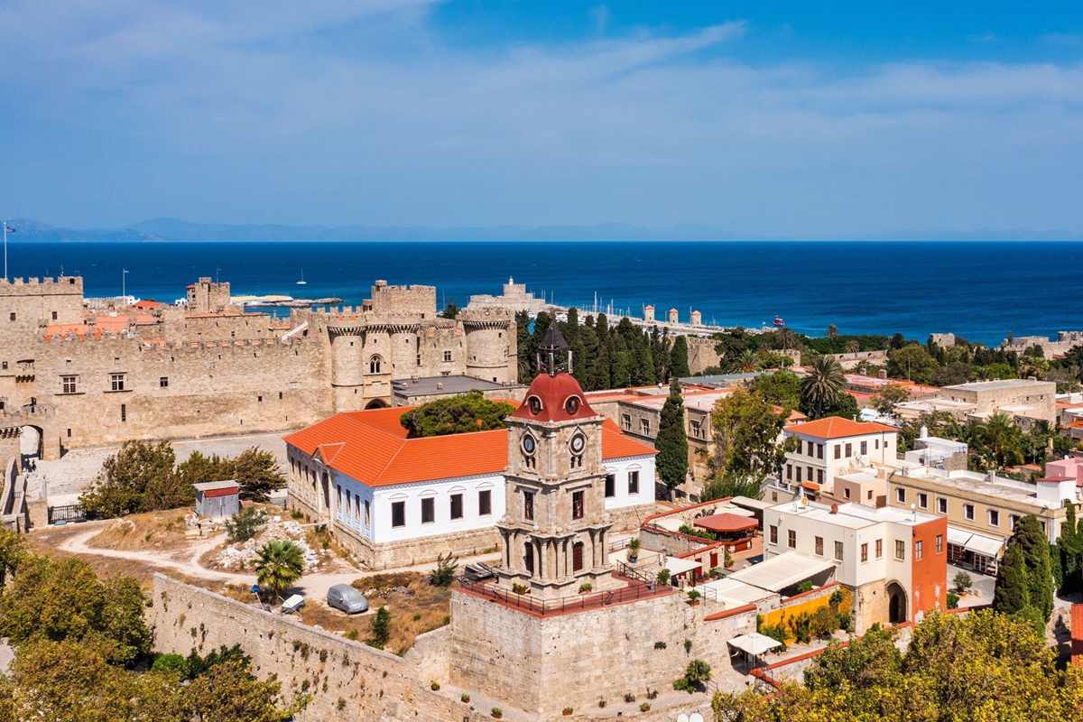
UNESCO sites in Greece embrace the Medieval City of Rhodes, built from around 1309 to 1523. Medieval describes the long age that came between ancient and modern times. The old town lies inside the island’s modern capital, also called Rhodes.
The upper town lies to the north, and the lower town spreads south-southwest of it. The knights of Rhodes belonged to the Knights Hospitaller, an order of Christian soldier monks. A wall 4 km long runs around the whole medieval city. That ring of stone guards this medieval part of the UNESCO sites in Greece.
Defence of each stretch of wall went to a different Langue, or tongue, of knights. Each Langue gathered knights of one language or homeland, such as France or Spain. The builders took the Theodosian walls of Constantinople as their model. Those walls of the Byzantine capital had long held out against attack.
In 1480, Mehmed II laid siege to Rhodes, bringing 100,000 troops and 170 ships. His army was driven back by the knights and their strong walls. Mehmed II was the Ottoman sultan who had already captured Constantinople. During a siege, attackers ring a walled place and try to starve or batter it into surrender.
- Listed: The medieval city joined the UNESCO sites in Greece on the World Heritage list in 1988.
- Living town: With over 6,000 residents, it is Europe’s largest medieval town still in active use.
- Protected: In 1960 the Ministry of Culture made the entire medieval town a protected monument.
Here, among the UNESCO sites in Greece, Rhodes kept its defences fixed in their 1522 form. As a result, they show the shift from classic medieval walls to modern defences. Fortifications are walls, towers and other works built to defend a place.
Which of the UNESCO sites in Greece stands on the rock pillars of Meteora?
The UNESCO sites in Greece feature Meteora, where monasteries stand on top of tall, sheer rock pillars. Locally, its monasteries rank just behind those of Mount Athos in importance. Monks share their daily life, work and prayer inside a monastery.
Conglomerate is a rock made of pebbles and sand cemented together. Here it formed from stone, sand and mud that streams carried into a delta at a lake’s edge. A delta is land built where a stream meets still water. Water, wind and extreme heat and cold then wore the vertical faults, or deep cracks, into huge pillars.
Early hermits lived in hollows in the rock towers, up to 550 metres above the plain. Hermits chose lives of solitude for religious reasons. Solitude means being alone. On Sundays they gathered for prayer in a chapel below a rock named Dupiani. A chapel is a small church or prayer room.
In 1344, Athanasios Koinovitis led a band of followers from Mount Athos to Meteora. He later became known as Athanasios the Meteorite. Mount Athos, another of the UNESCO sites in Greece, is a holy mountain of monks in northern Greece. A follower is a person who joins a leader and copies his way of life.
- Active houses: Varlaam, Saint Stephen, Holy Trinity and Great Meteoron still serve as monasteries within the UNESCO sites in Greece.
- Green walls: Thick plant growth sprouts from the sheer rock faces, fed by water held in cracks.
- Baskets and ropes: Until the 1600s, baskets on ropes lifted goods and people up to the monasteries.
Between 1356 and 1372, Athanasios set up the Great Meteoron monastery on a rock called the Broad Rock. The monastery is one of the houses that make up this entry among the UNESCO sites in Greece. Broad Rock is the name of one of the stone pillars.
How do monks and wild forests share the UNESCO sites in Greece on Mount Athos?
The UNESCO sites in Greece reach north to Mount Athos. The mountain and the larger part of its peninsula are an autonomous region, run by the monastic community. Autonomous means self-governing, with its own rules inside the wider Greek state.
Mount Athos rises to 2,033 metres, with steep slopes under dense forest. Geology deals with rocks and the make-up of the earth. In geology, the peninsula is a continuation of the Rhodope Mountains. That range spreads across northern Greece and Bulgaria. A peninsula means land jutting into the sea, joined to the mainland at one end.
Forests of black pine cover the higher ground of the mountain. Black pine is a dark-barked conifer, a cone-bearing tree. The mountain holds 350 species of mushroom. A species means one kind of living thing whose members can breed together. These fungi grow within the bounds of the UNESCO sites in Greece here.
The Great Lavra monastery was set up in 963 by a monk, Athanasius the Athonite. The Byzantine emperor Nikephoros II Phokas gave his support to the new house. Athonite means “of Athos”, linking the monk to the mountain. Today the Great Lavra forms part of the UNESCO sites in Greece on the Athos peninsula.
- Church link: In church matters, Athos answers directly to the Ecumenical Patriarch, the leading bishop of Constantinople.
- Wild mammals: The grey wolf, the wild boar and the Mediterranean monk seal all live on Athos.
- Lost fleet: Herodotus says a storm near Athos sank 300 Persian ships in 492 BC, with 20,000 men.
The architect Dinocrates proposed carving Mount Athos itself into a figure of Alexander the Great. The plan came after the death of Alexander, a Macedonian king who built a vast empire. The mountain stands today among the UNESCO sites in Greece.
Which UNESCO sites in Greece come from early Christian and Byzantine Thessaloniki?
The UNESCO sites in Greece hold a group of early Christian and Byzantine monuments in Thessaloniki. The city played an important part in Christianity during the Middle Ages. The official name calls them Paleochristian, a word meaning early Christian.
Thessaloniki’s early Christian buildings helped shape Byzantine art and building styles throughout the empire. Their influence also reached Serbia, a land to the north in the Balkans. The rise of imperial Byzantine building and the wealth of the city went hand in hand. Imperial here means linked to the emperor and his court.
The City Walls of Thessaloniki date from the 4th and 5th centuries. City walls were rings of stone built to keep attackers out of a town. The Church of Acheiropoietos goes back to the 5th century. A church is a house of Christian worship. Both the walls and this church belong to the UNESCO sites in Greece.
Travellers such as Paul Lucas described the rich store of Christian monuments in the city under Ottoman rule. Ottoman refers to the Turkish empire that later ruled the city. A monument is a building or structure kept for its history. Those monuments are today counted among the UNESCO sites in Greece.
- Latomou Monastery: This house of monks in Thessaloniki dates from the 6th century.
- Panagia Chalkeon: This church, whose name honours the Virgin Mary, dates from the 11th century.
- Saint Catherine: The Church of Saint Catherine in the city dates from the 13th century.
The Byzantine Bath, a public bath house, dates from the 14th century. A bath house was a building where people washed in warm water and steam. It sits with the walls and churches in the Thessaloniki group of UNESCO sites in Greece.
Which ruler founded Mystras, the hill town among the UNESCO sites in Greece near Sparta?
The UNESCO sites in Greece contain Mystras, a fortified hill town in the Peloponnese. William II of Villehardouin built its fortress on a spur of Mount Taygetos, near Lacedaemon, or ancient Sparta. A spur is a ridge that juts out from a mountain.
William ruled the Frankish Principality of Achaea. In 1262 the fortress passed to the Byzantines. It then became the seat of their governor in the Morea, the medieval name of the Peloponnese. In 1349 Mystras became a royal capital, when the first despot took charge. A despot here was a prince who ruled the region for the emperor.
The Chronicle of the Morea, a medieval history of the region, names the town Myzethras or Myzithras. In a chronicle, events are written down in the order they took place. Under Ottoman rule, foreign travellers mistook Mystras for ancient Sparta, a famous Greek city-state. A city-state was a city that ruled itself and its own lands.
In 1439 Gemistos Plethon, a scholar at Mystras, travelled to Florence with Emperor John VIII Palaiologos. Florence is a city in Italy. Plethon and other Mystras scholars influenced the Italian Renaissance. That movement revived classical art and thought across Europe. Mystras itself now ranks among the UNESCO sites in Greece.
- Venetian years: The Venetians held Mystras from 1687 to 1715, a break in Ottoman rule.
- Standing churches: The Peribleptos Monastery, St. George, the Hagia Sophia and St. Demetrios still stand at Mystras.
- Palace of the Despots: It is the sole Byzantine palace still in existence, a rare piece of the UNESCO sites in Greece.
Pines and cypresses make up the bulk of the greenery around the ruins. Cypresses are slim, upright evergreens. A pine is a conifer with long needles. Those trees cover the slopes of this ruined town, listed with the UNESCO sites in Greece.
Which finds and stories shape the UNESCO sites in Greece at Olympia?
The UNESCO sites in Greece list Olympia, a small town in the region of Elis on the Peloponnese. Its official name is Archaia Olympia, Greek for “Ancient Olympia”. Beside the town lie the ruins of the ancient sanctuary of Olympia.
Despite its name, Olympia lies far from Mount Olympus, which rises in the north of Greece. Mount Olympus was thought to be home to the twelve Olympian gods. Pisa and Elis, two other villages nearby, competed with Olympia to run the precinct. Olympia, today a name on the UNESCO sites in Greece list, won that contest.
The Altis, the sacred precinct, was an irregular four-sided area that measured over 183 metres along each side. Walls closed it in, except on the north, where Mount Kronos bounded it. Today trees grow over the site, chiefly the Judas-tree, a low tree with pink flowers. Its Latin name is Cercis siliquastrum.
Modern research suggests repeated tsunamis buried the site under sea water. A tsunami is a huge sea wave set off by an earthquake or landslide under water. The clues are shells of molluscs and snails and tiny sea creatures called foraminifera. Earlier scholars had thought river floods buried the ruins.
- German digs: Since the 1870s, the German Archaeological Institute in Athens has run the digs and care of the site.
- Last Games: Olympia, now among the UNESCO sites in Greece, kept its festival until the last Olympiad in 393 AD.
- Bronze bull: In 2021 a bronze bull figurine 2,500 years old was found near the temple of Zeus.
The ancient site of Olympia once held over 760 significant buildings. Ruins of a large share of those buildings survive at the site today. Significant here means important enough to be worth recording. Those ruins stand today within the UNESCO sites in Greece.
What do the UNESCO sites in Greece owe to the sacred island of Delos?
The UNESCO sites in Greece extend to the island of Delos. In listing it, UNESCO said its ruins give the picture of a great cosmopolitan port of the Mediterranean. Cosmopolitan means full of people and ideas from different lands and cultures.
Among the UNESCO sites in Greece, Delos has an early story told by Thucydides, an Athenian historian. He says the first people there were Carians who lived as pirates. King Minos of Crete later drove them out. From 900 BC to 100 AD, Dionysus and Leto were worshipped there at a major cult centre.
In the 6th century BC, the Athenian ruler Pisistratus had the island purified. All graves within sight of the temple were dug up, and the bodies went to a nearby island. Two tombs, those of the Hyperborean Maidens, were spared because a hero cult surrounded them. A hero cult is worship paid to a dead hero.
Trade routes had shifted before the first century BC ended. Puteoli took the place of Delos as the hub of Italian commerce with the east. Puteoli was a port town in Italy, near Naples. As a cult centre, too, the island then entered a sharp decline. Delos still stands among the UNESCO sites in Greece.
- Minoan Fountain: This rectangular public well was cut into the rock, with a column at its centre.
- Apollo kouros: One hand of this giant young-man statue stays on Delos, while the British Museum holds a foot.
- House of Dionysus: This house is named after a floor mosaic showing Dionysus on the back of a panther.
Three cone-shaped mounds stand in sight of the Sacred Harbour. They mark landscapes held sacred to a goddess, thought to be Athena. Athena was the Greek goddess of wisdom and war. The harbour and mounds belong to the island now counted among the UNESCO sites in Greece.
Why did the Pythagoreion join the UNESCO sites in Greece in 1992?
UNESCO sites in Greece gained the Pythagoreion in 1992, listed with the nearby Heraion of Samos. The Pythagoreion holds what remains of ancient Samos town, on the island of the same name. An archaeological site is ground where experts study traces of earlier people.
The ruins lie inside the modern town of Pythagoreio. The site takes its modern name from that town. Among the UNESCO sites in Greece, it mixes ancient Greek and Roman monuments with a famous old tunnel. A monument is a structure kept for its history. A tunnel is a passage cut through rock or earth.
The oldest finds at this entry among UNESCO sites in Greece date to the 4th millennium BC. That was during the Neolithic Period. A millennium means ten centuries. The Neolithic Period was the last stage of the Stone Age, when farming began. Dates marked BC run backwards toward the start of the Christian calendar.
Its place among the UNESCO sites in Greece rests on the cultural, military and economic weight of Samos. That weight belongs to Archaic and early Classical Greece. The Archaic age is the stage of Greek history just before the Classical age. Economic means linked to trade, money and work. Military means linked to armies and war.
- Walls: Defensive walls, called fortifications, ring the ancient town and date from the Classical Period.
- Street plan: Excavations revealed the ancient street plan, a sewage system, and public and religious buildings.
- Roman remains: Roman builders left an agora, or open market square, plus a stadium, town houses and public baths.
Modern Pythagoreio has a museum that displays over 3000 objects. They present the growth of ancient Samos and its rural lands. The earliest date to the 4th millennium BC, and the latest to the 7th century AD. Rural refers to farms and open country.
What makes the Heraion of Samos one of the UNESCO sites in Greece?
UNESCO sites in Greece took in the Heraion of Samos in 1992, along with the nearby Pythagoreion. The Heraion was a sanctuary of the goddess Hera on the island of Samos. A sanctuary is holy ground kept for honouring a god.
Cult activity at the Heraion, now among the UNESCO sites in Greece, goes back to about 1700 BC. A cult here means rites honouring a god. Worship of Hera at the sanctuary ended in AD 391. That happened when the Theodosian edicts forbade pagan worship. Edicts are official orders, and pagan means of the old gods.
Statues given to the Heraion included the Kouros of Samos. Its height of about three times life size places it among the largest known kouroi. A kouros is an over-life-size statue of a naked young man; kouroi is the plural. An inscription on its thigh says that Isches son of Rhesus dedicated it.
Among the UNESCO sites in Greece, the Heraion kept wooden votives safe in waterlogged soil. A large number of them date from the Archaic period. Waterlogged means soaked through with water. A votive is a gift to a god, in thanks or hope. Almost no other wooden objects of that period have been found in Greece.
- Louvre: One kore, a statue of a young woman, from the Cheramyes group is now in the Louvre.
- Ship: Excavators found a full-size ship’s hull, roughly 20 metres long, built in the late seventh century BC.
- Writing: The Hazael frontlet, a bronze ornament for a horse, bears the oldest alphabetic writing found in Greece.
The Heraion, one of the UNESCO sites in Greece, gained a Christian church in the fifth century AD. Through the Byzantine period, the site served as a quarry. A quarry is a pit where stone is cut. Byzantine describes the later Roman state centred on Constantinople.
Which royal story does Vergina bring to the UNESCO sites in Greece?
UNESCO sites in Greece include Aigai, the ancient city found at Vergina in Greek Macedonia. UNESCO sees in Aigai the change from rule by city-states to the empires of Hellenistic and Roman times. In a city-state, one city governs itself together with its farmland.
By 1000 BC, a cluster of villages lay within 7 km of where the city later stood. Together they made a major population centre, a dense group of homes and people. Aigai, today on the list of UNESCO sites in Greece, stayed small as a city. Its people lived chiefly in nearby villages.
From 513 to 480 BC, Aigai formed part of the Persian Empire. An empire joins different lands and peoples under a single ruler. Life at Aigai later reached great luxury. Merchants brought perfume, carved ornaments and jewellery from across the ancient world to serve the court. A court is the circle of people around a king.
Royal tombs now among the UNESCO sites in Greece suffered a raid in 276 BC. The raiders were Gallic mercenaries, or hired soldiers, serving Pyrrhus. They plundered a large number of the tombs. Early in the third century BC, Antigonos Gonatas raised the great tumulus to shield the royal tombs. A tumulus is an earth mound over graves.
- City wall: The wall around the city went up in the 5th century BC.
- Landslide: In the 1st century AD, a landslide wiped out what people had rebuilt at Aigai.
- First dig: Early excavations at the site stopped because of the risk of malaria, a fever spread by mosquitoes.
Digging at Aigai, one of the UNESCO sites in Greece, restarted in 1937 under the University of Thessaloniki. A university is a school of higher learning that also carries out research. Excavation means careful digging that uncovers and records buried remains.
What does Mycenae add to the UNESCO sites in Greece?
UNESCO sites in Greece gained Mycenae in 1999, and nearby Tiryns was added alongside it. UNESCO pointed to its role as the centre of the Mycenaean civilisation. A civilisation is an advanced society with towns, rulers and shared ways of life.
The name Mukanai, borne by one of the UNESCO sites in Greece, is thought to be pre-Greek. Later Greek speakers inherited it. Homer tied the name to the nymph Mycene, whose father was the river god Inachos. Nymphs were female spirits of springs, trees and rivers in Greek myth. Homer was the poet of the Iliad.
This entry among UNESCO sites in Greece was lived in without a break from the Early Neolithic. That phase ran from about 5000 to 4000 BC. The word Neolithic refers to the New Stone Age, the time farming spread. Continuous occupation means that people lived there in every period, with no long gap.
Surviving evidence suggests that the Mycenaean kingdom was divided into sixteen districts. A district is one area of a kingdom, run as a single unit. Mycenae’s palace is thought to have ruled two to three times more land than other palace states. A palace state was a kingdom governed from a royal palace.
- Persian Wars: A force from Mycenae fought at Thermopylae and at Plataea during the Persian Wars.
- Care: A scientific committee for Mycenae was set up in 1999 to preserve and steady the remains.
- Protection: Ministerial Decree No 2160 of 1964, a government order, fixed the protected limits of Mycenae.
From 1796, Napoleon’s invasion of Italy pushed members of the Society of Dilettanti to seek other places. They began to add Mycenae, now one of the UNESCO sites in Greece, to their journeys. Their Grand Tour, a long journey of study, had normally taken place in Italy.
Why do the walls of Tiryns matter to the UNESCO sites in Greece?
UNESCO sites in Greece took in Tiryns in 1999, listed together with the ruins of Mycenae nearby. The site is best known for its palace, its Cyclopean tunnels and, above all, its walls. Cyclopean describes walls built of huge, roughly shaped stones.
The acropolis of Tiryns, one of the UNESCO sites in Greece, rose in three building phases. An acropolis is a fortified upper town on a hill. Its palace held a megaron, the great hall of a Mycenaean palace. Two of the three megaron walls were later built into an archaic temple of Hera. Archaic means very early.
Among the UNESCO sites in Greece, Tiryns keeps the bases of its walls along their full length. In places the walls still stand 7 metres high. Their first height is put at 9 to 10 metres. Their thickness is 6 metres as a rule. Where tunnels pass through, it reaches 17 metres.
Herodotus reports a defeat of the Argives, the people of Argos, by Cleomenes I of Sparta. After that, their slaves held Tiryns for a long time. In 468 BC, Argos destroyed both Mycenae and Tiryns. Pausanias says the people of Tiryns were moved to Argos to swell its population. Herodotus and Pausanias were ancient Greek writers.
- Tunnels: Tunnels with triangular roofs gave the people of the lower city a refuge in danger.
- Decoration: The outer arcade had a lower band of alabaster, a soft pale stone, carved with rosettes and flowers.
- Excavation: Heinrich Schliemann first judged the palace to be medieval and nearly destroyed its remains.
Long before it joined the UNESCO sites in Greece, Tiryns was a flourishing pre-Hellenic settlement. It was the middle of the 3rd millennium BC. Pre-Hellenic means before the Greeks. The hill below it was 300 metres long and no more than 18 metres high.
How did Patmos earn a place among the UNESCO sites in Greece?
UNESCO sites in Greece gained three linked places on Patmos in 1999. One is the town of Chora, and another is the Cave of the Apocalypse. The third member is the monastery of Saint John, called the Theologian. Patmos itself is an island of the Aegean.
The UNESCO sites in Greece on Patmos owe their listing to the monastery’s sacred significance. Its unbroken growth in building style counted too. UNESCO also praised the rare survival of early Christian customs there. From its founding, the monastery took in the town of Chora, which grew up around its fortified walls.
Patmos, home to three UNESCO sites in Greece, sits near the northern edge of the Dodecanese. The name Dodecanese comes from Greek words meaning twelve islands. Patmos rarely appears in ancient texts, so its first people remain little known. Ancient texts here means the writings of Greek and Roman authors.
Building work on the monastery started in 1101. Monks are men who live apart for prayer, and a monastery is their shared home. Under Ottoman rule, the monastery enjoyed tax-free trade. Ottoman imperial papers kept in its Library confirm that right. A library is a room or building where books and papers are stored.
- Islands: Arkoi and Marathos, two islands off the coast, also fall within the municipality of Patmos.
- Revelation: Christians hold that John of Patmos had his visions on this island and recorded them as Revelation.
- Villages: Other settlements on Patmos, beyond the main towns, are Grikou and Kampos.
After the death of John of Patmos, early Christians built a number of basilicas on the island. Basilicas are long churches divided into aisles by columns. Centuries later, one of the UNESCO sites in Greece took shape there: the Monastery of Saint John.
Which Venetian traces make the Old Town of Corfu one of the UNESCO sites in Greece?
UNESCO sites in Greece gained the Old Town of Corfu in 2007. An old town is the historic core of a city, kept from earlier centuries. Corfu is the name of both the city and the island it stands on.
Venetian nobles ruled Corfu from 1386 to 1797. The Old Town, now among UNESCO sites in Greece, reflects that era. It has multi-storied buildings on narrow lanes. Inside the walls space was tight, so the cobblestone streets, called kantounia, are narrow. Certain lanes are too tight even for cars. Cobblestones are rounded stones set into a road.
Experts from ICOMOS assessed the Old Town ahead of its entry into the UNESCO sites in Greece. They found that about 70% of its pre-20th-century buildings date from the British period. Pre-20th-century means built before the twentieth century began. The British period was the time when the island was under British protection.
Spiridon, the patron saint of the island, lies in a tomb in his own church. That church is one of thirty-seven Greek churches in the city. A patron saint acts as a heavenly protector for a place. Will Durant claimed that Corfu alone in Greece escaped Ottoman conquest. He credited the Republic of Venice for that.
- Liston: One explanation traces the name Liston to a Venetian word meaning evening promenade.
- Woman mayor: Maria Desylla-Kapodistria, in office from 1956 to 1959, was the first woman mayor in Greece.
- Mayors: Up until 1866, Corfu had no mayors, so its list of mayors starts in that year.
Among the UNESCO sites in Greece, Corfu counts as a quintessential fortified maritime city. Experts credit its layout and its Venetian walls. Quintessential means the purest example of its kind. Maritime describes a place shaped by the sea and shipping, and fortified means walled for defence.
When did Philippi become one of the UNESCO sites in Greece?
UNESCO sites in Greece took in the ruins of ancient Philippi in 2016. Its first settlement, Crenides, grew below Mount Orbelos, known today as Mount Lekani. A settlement means a group of homes founded by settlers. Kavala lies about 13 km to the south-east.
New gold mines at Asyla added to the wealth of the Macedonian kingdom. A mine is a dig for metal or stone. Philippi, now among the UNESCO sites in Greece, kept its own self-rule inside the kingdom of Macedon. Its own institutions included the Assembly of the demos. Demos is the Greek word for the people.
Amphipolis, not Philippi, became capital of the eastern Macedonian state under Roman rule. The capital of a state holds its government. Among the UNESCO sites in Greece, Philippi holds a little temple over the tomb of one Exekestos. He was honoured as the ktistes, the hero who founded the city.
Under Rome, Philippi, listed today among UNESCO sites in Greece, was run by two duumviri. These military officers were appointed directly from Rome. Duumviri is the Latin word for two men. Latin inscriptions in abundance show the prosperity of the city. Inscriptions are texts carved into stone or metal.
- Cathedral: A cathedral built around an octagonal, or eight-sided, church rivalled the churches of Constantinople.
- First report: Georges Perrot published the first modern archaeological description of the site in 1860.
- Siege: In 473, Ostrogothic troops besieged the city but failed to take it.
From 1914 to 1937, French excavators uncovered the Greek theatre, the forum and Basilicas A and B. They also cleared the baths and the walls. Basilicas are long halls, here used for Christian worship. Excavators are people who dig up and record ancient remains.
Why is Zagori counted among the UNESCO sites in Greece?
UNESCO sites in Greece gained Zagori in September 2023. UNESCO placed it on its list of Cultural Landscapes. Its architecture stands as a typical model of the old stone-built settlements of the area. A cultural landscape is land shaped by people working with nature.
The Zagorisian League, or Koinon, formed after a treaty of 1431 with Sinan-Pasha. The Greek term koinon means a common body or league. Treaties are formal pacts between two or more sides. The arrangement that gave Zagori its self-rule was called Voiniko. Self-rule means a people running its own affairs.
For the league of Zagori, now among UNESCO sites in Greece, a treaty of 1670 renewed its terms. Under it, Zagori held special privileges called Surutia. A privilege is a right given to one group alone. Western Zagori joined the treaty in the 17th century. By 1678 the villages under the treaty numbered 60.
Zagori, one of the UNESCO sites in Greece, keeps songs of mourning called moirologia. They accompany laments for the dead. Bones are taken up again once one to three years have passed. They are washed, perfumed and laid in a wooden larnax in a village ossuary. A larnax is a bone chest; an ossuary stores such chests.
- Bell towers: In Zagori, the campanile, or bell tower, stands apart from the church as a rule.
- Winter room: The mantzato, the chief room for winter, holds the fireplace of a Zagori house.
- Care: Since the 1980s, state projects have aimed to keep the villages’ traditional character.
Byzantine rulers also endowed monasteries in the area now listed among UNESCO sites in Greece. The monastery of St John of Rogovou, near Tsepelovo, was founded in 1028. Its founder was the sister of Emperor Romanos III. An endowment is a gift of land or money.
How does Knossos fit into the UNESCO sites in Greece?
UNESCO sites in Greece now include Knossos within a serial property named Minoan Palatial Centres. A serial property joins sites in different places under one listing. That property covers six Cretan palace sites in all, with Kydonia, Malia, Phaistos, Zakros and Zominthos.
Under criteria ii, iii, iv and vi, the Minoan centres joined the UNESCO sites in Greece. Criteria are the tests a place must meet for listing. UNESCO also counts Linear A and Cretan Hieroglyphic among the earliest writing systems of Europe. Both were created in Crete at the start of the second millennium BC.
Minoan rulers at Knossos kept records in Cretan hieroglyphs and Linear A. Linear A remains undeciphered, so no one has yet managed to read it. In Linear B, a later script, the city’s name appears as Ko-no-so. A script is a set of written signs used for a language. Undeciphered means not yet decoded.
Minoan columns at Knossos, one of the UNESCO sites in Greece, tend to taper downward. Later Greek columns do not. To taper is to grow narrower toward one end. They were mostly timber, set on stone bases and topped with rounded capitals. A capital is the wide top part of a column.
- City-state: Through the Archaic and Classical ages, Knossos stood as a leading city-state of Crete.
- Roman era: Under Rome, Gortyn rose above Knossos as the leading political centre of Crete.
- Growth: From about 3000 to 1900 BC, before the first palace, Knossos became larger and more complex.
Prepalatial means the age before the first palaces. At its end, older buildings on Kephala hill were levelled or reorganised. That work created the platform for the palace now counted among UNESCO sites in Greece. A platform here is a flat base for building.
What does Zakros on eastern Crete give the UNESCO sites in Greece?
UNESCO sites in Greece count Zakros among their Minoan entries. UNESCO has designated the site a World Heritage Site. Its ruins stand on Crete’s east coast, in the Lasithi area. Minoan is the label for Crete’s great civilisation of the Bronze Age.
The Ravine of the Dead cuts through both the higher and the lower parts of the site. It takes its name from the burials found in caves along its walls. A ravine is a deep, narrow valley cut by water. Scholars have proposed Dikta as the ancient name of the site.
At Zakros, one of the UNESCO sites in Greece, an earthquake destroyed the New Palace around 1450 BC. During the Minoan era, the sea level dropped four times, or else the land rose. For a harbour city, that change was of major significance. A harbour is sheltered water where ships can lie safely.
The town at Zakros, now among UNESCO sites in Greece, followed a rectilinear plan of paved roads. Rectilinear means made of straight lines. The palace itself had two big paved courts, a central one and a western one. A court, in this sense, is an open yard inside a building. Paved means covered with flat stones.
- Egyptian bowls: Two Egyptian bowls of the Early Dynastic age lay in the palace store for sacred objects.
- Copper: Copper ingots, or cast blocks, shaped like an ox hide date to the Late Minoan IA phase.
- Early villa: A Minoan villa on the road from Epano Zakros dates from before the palace was built.
Among the UNESCO sites in Greece, Zakros has yielded seals, chiefly of steatite, along with clay sealings. Steatite is a soft stone, also called soapstone. A seal is a carved stone pressed into soft clay, leaving a mark called a sealing.
How does the Temple of Athena Nike enrich UNESCO sites in Greece?
UNESCO sites in Greece include the Temple of Athena Nike on the Acropolis of Athens. Built around 420 BC, it is the oldest fully Ionic temple on that hill. Ionic names an order, or style, of columns with curled, scroll-like tops.
Greek myth made Nike the goddess of victory. Athena was worshipped here in that form, as a winner in war. A cult is the worship of one god. A priestess ran the cult at this shrine, now part of the UNESCO sites in Greece. She was appointed by democratic allotment, which means a draw by lot.
The architect Kallikrates designed this temple among the UNESCO sites in Greece. It is tetrastyle, a Greek term for a front of four columns. It is also amphiprostyle, with a porch of columns at the front and the rear. The building ran 8 metres long and 5.5 metres wide. It stood 7 metres tall.
A frieze is a carved strip of figures running high along a building. The south frieze of this temple shows Greeks defeating the Persians in the battle of Plataea. The Persians came from a large empire to the east of Greece. Plataea was a Greek city, and the battle took its name.
- Marble: Builders used white marble and raised the temple in stages, as war-strained funds allowed.
- Rebuilding: In 1834 the German archaeologist Ludwig Ross put the temple back together.
- Parapet: Around 410 BC, a low wall was added to stop people falling off the steep bastion.
The Acropolis of Athens and Delphi were the second and third UNESCO sites in Greece to be listed. Both joined the list in the same year. A listing marks a place of outstanding value to humanity. The Temple of Athena Nike shares that Acropolis listing.
Which story does the Propylaea tell among UNESCO sites in Greece?
UNESCO sites in Greece include the Propylaea, the ceremonial Doric gateway to the Acropolis of Athens. Its Greek name means ‘that which is before the gates’. Doric is the plainest Greek column style, with cushion-shaped tops. Ceremonial means used for formal rites and processions.
The writer Plutarch named Mnesikles as architect of this gate among UNESCO sites in Greece. Mnesikles was also the architect of the Erechtheion. His first plan for the gatehouse held five halls. A central hall was to carry the route of processions to the Acropolis. A procession is a formal parade of people.
The Propylaea had no carved decoration, and its metopes and pediments stayed bare. A metope is a square wall panel; a pediment is a gable triangle. At the north end of the entrance stood the Hermes Propylaios, a work of the sculptor Alkamenes. Hermes was the messenger of the gods, and Propylaios means ‘of the gateway’.
Among UNESCO sites in Greece, this gateway holds a chamber in its north-west wing. The scholar John Travlos showed that seventeen dining couches fit end to end around its four walls. Ancient Greeks reclined on such couches to eat at formal meals. His view is now the consensus, meaning the shared view of experts.
- Older gates: The Propylaea was the last in a line of gatehouses built on the citadel.
- Roman stairway: Under the emperor Claudius, around 42 AD, a straight marble stairway was built.
- Bronze lioness: An early bronze lioness, called the Leaina, stood near the north wall of the gate.
UNESCO sites in Greece count as cultural heritage when they hold monuments, groups of buildings or sites. A monument here means a work of architecture, a large sculpture or an inscription. The Propylaea fits the first kind, as a work of architecture.
Why does the Great Meteoron stand out among UNESCO sites in Greece?
UNESCO sites in Greece include three mixed properties, and Meteora is one of them. Mixed means listed for both natural and cultural value. The Monastery of Great Meteoron is part of that Meteora listing. A monastery is where monks live and pray together.
The Great Meteoron, a Greek Orthodox house of monks, stands close to the town of Kalambaka. Greek Orthodox names the eastern Christian church of Greece. The town lies in Thessaly, at the heart of mainland Greece. Among UNESCO sites in Greece, this house counts as one of the oldest surviving Meteora monasteries.
A local lord named Simeon Uroš sponsored the founding of the Great Meteoron. A lord is a noble who rules land and people. Simeon Uroš was based in nearby Trikala. A sponsor gives money or support to a project. His backing helped start a monastery that now belongs to UNESCO sites in Greece.
Emilianos Vafidis led the Great Meteoron as abbot between 1961 and 1973. An abbot is the head monk of a monastery. In 1973 he moved to Simonopetra and became its abbot. His disciple Alexios then led the Great Meteoron from 1973 to 1976. A disciple is a pupil who follows a teacher.
- Devil’s Tower: A tall rock known as the Devil’s Tower rises directly south of the monastery.
- Ypsilotera Rock: Beside that tower, the remains of a former monastery sit on Ypsilotera Rock.
- Hermitages: In the 11th century, religious groups built hermitages, homes for lone hermits, below the cliffs.
The Meteora monasteries were built mainly close to the Great Meteoron. Two exceptions are Saint Stephen and Holy Trinity, which lie further to the south. So the Great Meteoron sits among a cluster of houses within these UNESCO sites in Greece.
How does the Church of the Acheiropoietos fit into UNESCO sites in Greece?
UNESCO sites in Greece gained the Church of the Acheiropoietos in Thessaloniki in 1988. UNESCO chose it for its outstanding early Byzantine architecture. Byzantine refers to the Christian empire ruled from Constantinople. It was listed together with other early Christian and Byzantine buildings in Thessaloniki.
Among UNESCO sites in Greece, the church stands in central Thessaloniki and dates from the 5th century. Its bricks and mosaics point to a date between 450 and 470. Mosaic is the craft of setting tiny coloured stones or glass into a surface. That date makes it possibly the oldest church still standing in Thessaloniki.
The building is a basilica, a long hall church, with three aisles. An aisle is a lengthwise passage of the hall. It measures 36.5 metres long and 28 metres wide, under a wooden roof. Rows of columns divide the aisles, and each side aisle carries a gallery above it. A gallery is an upper floor.
The Ottomans took Thessaloniki in 1430. After that, the Acheiropoietos became the first church in the city turned into a mosque. Sultan Murad II made the change himself. A sultan was the ruler of the Ottoman Empire. Muslims gather to pray in a mosque. Both faiths used this building among UNESCO sites in Greece.
- Marble: Green Thessalian marble columns stand in the tribelon, a triple-arched opening into the main hall.
- Frescoes: Early 13th-century wall paintings, or frescoes, of the Forty Martyrs of Sebaste decorate the south side.
- Roman bath: Under the north aisle, diggers found three layers of mosaic floors from an older Roman bath.
The name Acheiropoietos means ‘not made by hands’ in Greek. The name first appears in records in 1320, presumably after an icon of that kind. An icon is a sacred painting. So an icon named a church among the UNESCO sites in Greece.
What role does the Great Lavra play among UNESCO sites in Greece?
UNESCO sites in Greece take in Mount Athos, where the Great Lavra was the first monastery built. Mount Athos rises on the Athos peninsula, in the region of Macedonia in north-eastern Greece. The word peninsula names a stretch of land with water around three sides.
An ancient city of the Athos peninsula once stood on this site, possibly Akrothooi. Sarcophagi from that city now rest in the monastery’s oil storage house. A sarcophagus is a stone coffin. Later, Byzantine emperors gave the Great Lavra large estates of land. These gifts let the number of monks rise from 80 to 120.
In the 11th century, the Great Lavra held 700 monks. Emperors favoured its growth in that age. The house has followed a cenobitic rule since 1980. Cenobitic life means monks share meals, work and goods in one community. This shared rule now shapes daily life at this house among UNESCO sites in Greece.
Mount Athos is still a leading centre of Eastern Orthodox monastic life. Monastic life is a way of living in which monks withdraw from the world to pray. Eastern Orthodox names the Christian churches of Greece and eastern Europe. Mount Athos also holds recognition as one of the UNESCO sites in Greece.
- Founder’s grave: North of the entrance hall, a chapel to the Forty Martyrs of Sebaste holds Athanasius’s grave.
- Saint Nicholas chapel: South of the entrance hall, Franco Cantellano painted the chapel of Saint Nicholas in 1560.
- Golden gospel: A gospel book with a golden cover was a gift from Emperor Nikephoros II Phokas.
A plant species, Campanula lavrensis, takes its name from the Great Lavra. Campanula is the Latin name for the bellflowers, plants with bell-shaped blooms. Lavrensis means ‘of Lavra’ in this plant name. The plant thus honours a house among the UNESCO sites in Greece.
Which Serbian story does Hilandar bring to UNESCO sites in Greece?
UNESCO sites in Greece include Mount Athos, home to twenty Eastern Orthodox monasteries. Hilandar is one of them and the only Serbian Orthodox monastery there. The Serbian Orthodox Church is the Christian church of the Serb people. Hilandar’s Greek name is Moni Chilandariou.
Stefan Nemanja and his son, Saint Sava, founded Hilandar in 1198. Both men came from the Grand Principality of Serbia. A principality is a state ruled by a prince. Hilandar was also the first Serbian hospital and university. A hospital is a place that cares for the sick. A university teaches students at the highest level.
Violence swept Mount Athos in the first decade of the 14th century. Of 300 monasteries and monastic groups there, only 35 came through, Hilandar among them. In 1320 King Stefan Milutin rebuilt the main church in its present shape. It became a symbol of Hilandar among UNESCO sites in Greece.
UNESCO sites in Greece gained Mount Athos for its religious importance. The listing also named the well-kept architecture of its monasteries. A third reason was the care given to the natural setting of the peninsula. Architecture means the design and building of structures. Natural setting here means the land, plants and wildlife around the monasteries.
- Name: The name Hilandar seems to come from chelandion, a Greek word for a Byzantine transport ship.
- Monks: About 45 working monks live and serve in the monastery today.
- Land: Since the 14th century, Hilandar has owned one fifth of all the land on Mount Athos.
Hilandar treats the Icon of the Three Hands, an image of the Mother of God, as its abbess. An abbess is a woman who heads a religious house. So a holy image leads this house among the UNESCO sites in Greece.
How do the fortifications of Rhodes shape UNESCO sites in Greece?
UNESCO sites in Greece include the medieval town of Rhodes, held inside a ring of old walls. The walled town is also a major draw for tourists. Medieval describes the Middle Ages, which lay between the ancient world and the modern age.
Around this part of UNESCO sites in Greece runs a huge earth bank faced with stone. It has a scarp, a moat, a glacis, a counterscarp and jutting bastions. A scarp is the inner face of a ditch; a counterscarp is the outer face. A glacis is an open bank sloping down from the defences.
Philo of Byzantium wrote a treatise on defensive works called the Paraskeuastica. A treatise is a long, careful written study of one subject. In the 3rd century BC, Philo spent time on the island and praised its walls. Later, Byzantine rulers raised a fortress on the town’s highest ground.
Grand Master Antonio Fluvian de Riviere, head of the knights, led the expansion of the walls. Builders completed the curtain of the wall between 1457 and 1465. A curtain wall is the stretch of wall that runs between two towers or bastions. This curtain encloses the old town among UNESCO sites in Greece.
- Italian experts: The knights called in Italian military architects, among them Matteo Gioeni and Gabriele Tadino da Martinengo.
- Ottoman care: After 1522 the Ottomans repaired the walls and kept them in order for four centuries.
- Malta: In Malta, the knights’ first walls at Birgu followed the style of the Rhodes defences.
Inside the walls lies Europe’s largest active medieval town, home to over 6,000 people. Active here means that people still live in it, rather than leaving it in ruins. Those residents make the old town a living part of the UNESCO sites in Greece.
What do the Peribleptos frescoes bring to UNESCO sites in Greece?
UNESCO sites in Greece gained the ruins of Mystras in 1989, with its fortress, palace, churches and monasteries. The Peribleptos Monastery, a late Byzantine house, is one of those monasteries. Late Byzantine refers to the final centuries of the eastern Roman Empire.
Manuel Kantakouzenos is thought to have built the monastery in the mid-14th century. He was the first Despot of the Morea. A despot was a Byzantine prince who governed a province, and the Morea is the Peloponnese. It takes its name from a renowned monastery in Constantinople, the Byzantine capital.
The frescoes in the main church date from 1348 to 1380. Fresco painting puts colour onto fresh, damp plaster. Plaster is a paste of lime that hardens on walls. Among UNESCO sites in Greece, they form a very rare surviving cycle of late Byzantine painting. A cycle is a linked series of scenes.
Builders set the monastery against a cliff face, with a cave holding up the structure. This way of building is known as the Mystras style. It appears in other churches and monasteries of the area. Buildings in this style resemble a castle. The style belongs to Mystras, one of the UNESCO sites in Greece.
- Stonework: The walls combine squared stones with tiles set into the masonry.
- Art schools: Scholars connect the frescoes with the Cretan and Macedonian schools of painting.
- Baptism scene: One fresco places Saint John the Baptist at the Baptism of Christ.
Among the monastery’s relics is the head of Gregory of Nazianzus, a saint. A relic is a holy object kept from a saint. Gregory served as Archbishop of Constantinople in the 4th century. His relic rests in one of the UNESCO sites in Greece.
What makes the Church of Hosios David part of UNESCO sites in Greece?
UNESCO sites in Greece include the Church of Hosios David in Thessaloniki, built in the late 5th century. The city lies in Central Macedonia, in the north of the country. Hosios is a Greek title for a holy person, close to the word saint.
In Byzantine times, the Latomos Monastery used this church as its katholikon. Katholikon is the Greek term for the chief church of a monastic house. Its patron saint is David the Dendrite. A dendrite was a hermit who lived in a tree. His name now marks one of the UNESCO sites in Greece.
Among UNESCO sites in Greece, the church’s apse keeps a 5th-century mosaic. The mosaic is named the Icon of Christ of Latomos. An apse is a curved recess behind the altar. Mosaic work sets tiny cubes of glass or stone into plaster. Tradition said that a miracle created this icon in the 3rd century.
In the Ottoman era, the church became a mosque. In 1921 Greek Orthodox worship returned, and the building was reconsecrated. Reconsecrated means blessed again for Christian worship. At that point it gained its present name, Hosios David. Mosques are Muslim places of worship. The Ottoman era was the age of Turkish rule in Greece.
- Plan: The first building used a cross-in-square plan, a cross set inside a square outline.
- Hidden murals: Murals found under plaster remain from frescoes of the middle Byzantine period, about 1160-70.
- Minaret: Only the base of the minaret, the mosque’s tower, and its spiral staircase survive today.
World Heritage Sites have legal protection under an international treaty that UNESCO runs. UNESCO is a United Nations agency. A treaty is a written pact signed by states. The Church of Hosios David shares that protection with the other UNESCO sites in Greece.
What did the Hippodrome of Olympia host within UNESCO sites in Greece?
UNESCO sites in Greece include Olympia and its Hippodrome. This course held the horse and chariot races of the ancient Olympic Games. A hippodrome is a track for horses. A chariot was a fast, light cart on two wheels, pulled by horses.
The starting place of the course took the form of a ship’s prow. A prow is the pointed front of a ship. At the start, an eagle figure rose and a dolphin figure fell. Then the barriers opened in turn until the horses lined up. Races began this way at one of the UNESCO sites in Greece.
The programme held a two-horse chariot race called the synoris. The apene was a race for carts pulled by mules. The kalpe was a race for mares, and foals had races too. A mare is a female horse, and a foal is a young horse. Women were able to win Olympic events by owning horses or chariots.
The hippodrome was long thought lost. The Alfeios river had flooded the area that Pausanias described and buried it in silt. Silt is fine mud that rivers leave behind. Pausanias wrote an ancient account of the sites of Greece. So the silt hid an Olympic racecourse among the UNESCO sites in Greece.
- 2008 survey: A team mapped the ground east of the sanctuary with magnetic sensors and ground radar.
- No ruins: No part of the race course survives above the ground today.
- Inventor: Pausanias credited a man named Cleoetas with the method of starting the races.
A World Heritage Site is first nominated by its host country. UNESCO’s World Heritage Committee then judges whether it qualifies. Nominated means formally put forward for a choice. Olympia went through those steps on its way to join the UNESCO sites in Greece.
Where in Corfu do UNESCO sites in Greece include the Old Fortress?
UNESCO sites in Greece cover the Old Fortress, a Venetian stronghold in the city of Corfu. It covers the promontory that first held the old town, which grew up in Byzantine times. A promontory is a raised point of land reaching out into water.
The Gothic invasion drove the Corcyreans to shelter behind walls on the peninsula at the city’s tip. The Goths were a Germanic people who attacked the Roman world. Corcyreans were the people of Corcyra, the ancient city of Corfu. No political or military events in the citadel are known from the 7th to 10th centuries.
In her book, the Alexiad, Anna Komnene called Corfu a city with very strong defences. The Byzantines fortified the western, higher peak around the 12th century. The Venetians later named that peak Castel a Terra, meaning the castle near the land. That peak lies closer to the town, within these UNESCO sites in Greece.
The eastern peak was known as Castel a Mare, Italian for ‘castle by the sea’. The Venetians also called it Castel Vecchio, the old castle. For a time it served as a powder magazine. A powder magazine stores gunpowder for guns and cannons. Both peaks rise inside the fortress, among UNESCO sites in Greece.
- New defences: After the 1537 siege, the Venetian governor ordered new bastions and towers that still stand.
- Silent captains: The two fortress governors swore never to contact each other during their two-year terms.
- 1923 attack: The Italian Air Force bombed the Old and New Fortresses during the Corfu Incident.
The old town of Corfu joined the UNESCO sites in Greece after an ICOMOS evaluation. ICOMOS is the International Council on Monuments and Sites, a body of heritage experts. An evaluation is a careful study that judges the value of a place.
What does the Lesvos Petrified Forest add to the UNESCO sites in Greece?
UNESCO sites in Greece include geoparks, which are areas known for their rocks, fossils and landforms. On Lesbos, the Petrified Forest is a major geosite of Lesvos Geopark. Petrified means turned to stone, and a geosite is one key spot inside a geopark.
The forest grew from plants and trees whose remains became fossils. Fossils are traces of past life kept in rock. Such remains turn up at spots across the western part of Lesvos. The fossil forest took shape between the Late Oligocene and the Lower–Middle Miocene. Both are names for ages of the Earth.
The earliest trees show subtropical plant life. Subtropical describes warm lands lying next to the tropics. That growth differs from the Mediterranean plant life found there now. Here, among the UNESCO sites in Greece, the Sigri pyroclastic formation is linked to fossilisation. Pyroclastic rock forms from volcanic ash and rock fragments.
As of 2014, the forest was proposed for the Tentative List of possible UNESCO sites in Greece. A Tentative List is the set of places that a country plans to nominate. To nominate means to put a place forward for World Heritage status. That status marks places of outstanding value to all people.
- Global list: The IUGS, a world body of geologists, named it in October 2022 among 100 geological heritage sites.
- Legal status: The area of the forest has been designated a protected natural monument.
- Volcanic ground: Neogene volcanic rocks, named after a span of Earth’s past, dominate central and western Lesbos.
In this corner of the UNESCO sites in Greece, the fossil plants are silicified. Silicified means that silica, a hard glassy mineral, took the place of the wood. They are remains of a subtropical forest that stood 20 to 15 million years ago.
How does the Sigri museum of the petrified forest serve UNESCO sites in Greece?
UNESCO sites in Greece link to Sigri, a village on Lesbos, through its geological museum. Named after the Lesvos Petrified Forest, this natural history museum helped found the European Geoparks Network. UNESCO’s Global Geoparks Network also counts it as a member.
Founded in 1994, the museum is a centre for studying, managing and preserving the petrified forest. It also teaches the public about the site. Its halls hold fossil trunks, branches, roots and leaves of trees. These finds show the rich biodiversity of Lesbos about 20 million years ago. Biodiversity is the mix of life in a place.
The displays explain volcanic activity, how fossils form and the palaeoenvironmental conditions. Palaeoenvironmental describes the setting of a place in the distant past. Within the UNESCO sites in Greece, the museum also runs a research and conservation centre. Its laboratories serve palaeontological studies, meaning scientific research on fossil remains.
Programmes and workshops reach schools and the general public. They focus on geology, environmental awareness and natural history. Geology covers the rocks of the Earth and the forces that shape them. The same work promotes sustainable development in the region of these UNESCO sites in Greece. Sustainable means meeting present needs without harming the future.
- Meetings: The museum hosts science conferences and seminars, and it works with partners abroad.
- Digital tools: Augmented reality, which lays digital images over real views, helps track how trunks are dug out.
- Aerial survey: Drones with 4K video cameras recorded the dig at different phases to map the site.
Among UNESCO sites in Greece, this museum’s exhibitions teach the geological history of the forest. They also explain the processes that created the stone trees. Geological history is the long record of how rocks and landscapes took shape over time.
Which story does Psiloritis Natural Park give the UNESCO sites in Greece?
UNESCO sites in Greece reach the centre of the island of Crete at Psiloritis Natural Park. The park is a UNESCO Global Geopark. Global Geoparks are areas whose rocks and landforms carry international value. Each one joins protection with education and local growth.
The park spreads over the Psiloritis mountain and its northern foothills. This stretch of the UNESCO sites in Greece runs all the way down to the Cretan Sea. Foothills are the lower hills that lead up to a high peak. In all, its land measures 1,159 square kilometres.
Among the UNESCO sites in Greece, this park is split between two prefectures, Rethymno and Heraklion. A prefecture was an older type of Greek district, much like a county. Its headquarters stand in the municipality of Anogeia. As a municipality, Anogeia elects a council that handles its local matters.
The European Geoparks Network has counted the park as a member since 2001. This network forms part of the wider UNESCO Global Geoparks Network. Universities around the world organise student field trips to the park, drawn by its geological features. A field trip is a lesson held outdoors, at the real place itself.
- Karst caves: Its caves, among them the Idaean Cave, link to karst, meaning limestone worn away by water.
- Minoan villa: The Zominthos plateau holds the highest-altitude villa of the Minoans, early Cretans, ever found.
- Pottery name: Kamares ware, a Minoan pottery style, is named after the Kamares cave, where early examples turned up.
Among UNESCO sites in Greece, the park works to conserve the natural and cultural heritage of Psiloritis. It backs geotourism, ecotourism and agrotourism as forms of sustainable development. Geotourism is travel made to see rocks, fossils and landforms. Agrotourism means trips that bring visitors to working farms.
How does Sitia Nature Park widen the map of UNESCO sites in Greece?
UNESCO sites in Greece reach the east of Crete with Sitia Nature Park. This park ranks as a UNESCO Global Geopark on the island. Its Greek name, Fysiko Parko Siteias, means Sitia Natural Park in English. Fysiko is the Greek word for natural.
The park is nearly coterminous with the municipality of Sitia. Coterminous means sharing the same borders. The naval base on the tip of Cape Sideros falls outside the UNESCO sites in Greece. Sideros is a cape, land that juts out into open water. The small islands off the coast are left out as well.
In essence, Sitia’s share of the UNESCO sites in Greece is mountainous. It holds the Sitia Mountains and their gorges, with the Coastal Hill Range of East Crete. Each gorge is a deep, tight cut between high rock walls. Much of the Thripti Mountains in the southwest was left out by mistake.
Among UNESCO sites in Greece, this park offers group caving in extensive cave systems, besides its two centres. Caving, also called spelunking, means exploring caves below ground. The park also leads group hikes over the peaks and gorges of eastern Crete. Both are arduous activities, meaning hard and tiring work for the body.
- Managing body: Geopark management passed to DOKAS, the municipal body for socio-cultural development in Sitia.
- Origins: DOKAS was formed in 2011 by joining smaller agencies under the Kallikratis plan for local government.
- Committee: A committee drawn from 11 agencies, not all of them public, handles daily management.
Members of the committee include the Natural History Museum of Crete and the Ephorate of Antiquities. An ephorate is a regional state office that cares for ancient remains. The Holy Monastery of Toplou and the Sitia Mountaineering Association also hold seats.
What makes the Samaria Gorge one of the UNESCO sites in Greece?
UNESCO sites in Greece take in the Samaria Gorge as a biosphere reserve. UNESCO’s world network of such reserves has listed the Gorge of Samaria since 1981. A biosphere reserve is an area that joins nature protection with local life.
The kri-kri, a goat found on Crete, ranges over the Samaria National Forest and the White Mountains. Around the gorge, that mountain range joins the UNESCO sites in Greece as a biosphere reserve. It hosts 14 more endemic animal species besides the kri-kri. Endemic means found in one place and nowhere else.
The kri-kri faced danger by 1960, when fewer than 200 remained. It is a feral domestic goat, meaning its tame ancestors went wild. Its line goes back to the first tamed goats of the Levant, from 8000 to 7500 BCE. The Levant is the eastern Mediterranean shore; BCE counts years before the Common Era began.
Agia Roumeli marks the exit of the gorge, a part of the UNESCO sites in Greece. It is a small village in southwest Crete. An old fortress called Castle Agia Roumeli crowns a hill to the west of the village. Fortresses were walled strongholds, built to hold out against attack.
- Rare shrub: Near Agia Roumeli, Fournoti beach has a small reserve set aside for a rare shrub, Hypericum aciferum.
- Gorge entrance: The gorge entrance lies at Xyloskalo, about 5 km from the small village of Omalos.
- Zeus legend: At Xyloskalo rise Gingilos, 2,080 m, and Volakias, 2,116 m, which legend ties to Zeus’s throne.
Crete, home to these UNESCO sites in Greece, still holds only about 2,000 kri-kri. The animals are considered vulnerable. Vulnerable is a conservation label for animals under clear threat of loss. Hunters, scarce grazing and disease all add to that risk.
Where does the Chelmos-Vouraikos Geopark sit among UNESCO sites in Greece?
UNESCO sites in Greece include the Chelmos-Vouraikos UNESCO Global Geopark, which is also a national park. Such parks are lands that the state guards for their nature. Its geosites, or key geological spots, carry special scientific, aesthetic and teaching value.
This geopark among the UNESCO sites in Greece lies in the northern Peloponnese. It reaches into the prefectures of Achaea and Korinthia. The Peloponnese is the large peninsula that forms southern mainland Greece. Its area is 654 square kilometres. Within that space live 27,125 people, spread over 62 municipalities.
Among UNESCO sites in Greece, this geopark has sinkholes, poljes, springs and caves as its chief features. A sinkhole forms when the ground drops into a gap in the rock below. A polje is a large flat basin in limestone country. Ladon’s eye is one such sinkhole. It holds a karst lake that reaches 47 metres deep.
Plant life is rich, with more than 1,100 species in the geopark. Each species is a single, separate kind of living thing. One of these plants, Globularia stygia, takes its name from the Styx waters geosite. In Greek myth, the Styx was a river of the underworld. The underworld was the land of the dead.
- UNESCO status: After reviews in 2013, 2015 and 2019, it has stood as a UNESCO Global Geopark since 2015.
- Deep time: Ten geological periods and three geotectonic zones, or rock belts formed by Earth movements, appear here.
- Birds: Here 149 bird species find shelter, either all year round or for part of it.
Trout and salmon farms operate within the area of these UNESCO sites in Greece. They turn aquaculture into a major human activity across the geopark. Aquaculture is the raising of fish or other water animals under controlled conditions for food.
Why do UNESCO sites in Greece include the Cave of the Lakes?
UNESCO sites in Greece count the Cave of the Lakes as a karstic geosite. It lies within the Chelmos-Vouraikos UNESCO Global Geopark. Karstic means shaped by water that dissolves limestone. Its rocks belong to the Tripolis zone and the Olonos-Pindos zone.
Among UNESCO sites in Greece, this cave sits close to Kastria, a village in the municipality of Kalavryta. Its older local name was Troupisio. At heart, it is a former underground river laid out on three levels. A level here is one floor of passages, stacked above or below another.
In winter, snowmelt changes the cave into a running river with waterfalls. A waterfall is water that drops over a steep step in rock. In the summer months the flow dries up. It leaves behind 13 lakes inside the cave. A lake here means a still pool of water held in the rock.
The ancient traveller Pausanias mentioned the cave in his writings. Pausanias was a Greek author who wrote about the places he visited. Greek legend says Melampus healed two of the king Proetus’s three daughters in this cave. Their names were Lysippe and Iphianassa. Proetus ruled Tiryns, an ancient city of Greece.
- Early people: Humans used the cave from the Neolithic, or New Stone Age, right through the Bronze Age.
- Fossil bones: On the lower level lie fossil bones of humans and animals, including the hippopotamus.
- Bat colony: Among UNESCO sites in Greece, this cave holds a winter colony of 18,000 bats.
Within these UNESCO sites in Greece, the Kastria Caves count as one of five Natura 2000 areas. That European Union network ties together protected nature areas across member countries. Its sites guard rare habitats, the places where wild species live and breed.
Which geology makes Mega Spilaio part of the UNESCO sites in Greece?
UNESCO sites in Greece include Mega Spilaio, a geosite of the Chelmos-Vouraikos UNESCO Global Geopark. Its listing names a fault and conglomerates. A fault is a crack where blocks of rock have shifted. Conglomerate is rock made of rounded pebbles cemented together.
Mega Spilaio means Great Cave in Greek. Officially it is the Dormition of the Theotokos Monastery. The Dormition is the falling asleep of the Virgin Mary, called the Theotokos. The monastery fills a large cave set in a steep, sheer cliff. Below it, the cliff falls to the Vouraikos river gorge.
Christian hermits lived in the cave during the first centuries of Christianity. A hermit lives alone for religious reasons. Within today’s UNESCO sites in Greece, tradition counts the monastery among the oldest in the country. The brothers Symeon and Theodore of Thessalonica are said to have founded it in 362. Thessalonica is the old name of Thessaloniki.
With the shepherdess Euphrosyne, the brothers found an icon of the Theotokos in the cave. Tradition holds that Luke the Evangelist painted it. An icon is a sacred image painted on a wooden panel. From about 1354 the monastery served as the home of the Orthodox Metropolitan of Patras. A metropolitan is a senior bishop over a region.
- Rebuilding: Large-scale damage struck in 849, 1400 and 1640, the year of a full rebuilding.
- New church: A fire in 1934 destroyed the katholikon, or main church, which a new church replaced in 1937.
- Feast days: This geosite among UNESCO sites in Greece holds feasts on 18 October, 14 September and 15 August.
After the Second World War, this geosite of the UNESCO sites in Greece was rebuilt from the ground. Today it rises as an eight-storey complex within a sheer cliff 120 metres tall. Each storey is a single level of the building.
How does Vikos–Aoös National Park extend the UNESCO sites in Greece into Epirus?
UNESCO sites in Greece reach the northwest with Vikos–Aoös National Park, created in 1973. The park is also a UNESCO Geopark in the region of Epirus. Epirus is a mountainous region that lies in the far northwest of the Greek mainland.
Among UNESCO sites in Greece, Vikos–Aoös counts as one of ten national parks on the mainland. It lies 30 kilometres north of the city of Ioannina, in the northern Pindus range. Its land spans 12,600 hectares of mountain country. Rivers, lakes, caves, deep canyons and thick forest fill that ground.
The Aoös Gorge lies near the town of Konitsa. The Aoös river runs between the mountains Trapezitsa, Tymphe and Raidovouni, forming a gorge 10 km long. The gorge holds one-arched stone bridges dating to the 17th through 19th centuries. Monasteries in the local style stand in this gorge among the UNESCO sites in Greece.
Drakolimni, which means Dragon Lake, is the biggest lake in the park. It formed after glaciers pulled back and lies 2,000 m up on Mount Tymphe. Alpine newts live in the high lakes of Tymphe, chiefly in Drakolimni. Local folktales link them with dragons and dragon battles. A newt is a small lizard-like water animal.
- Deep cave: Provatina cave, 408 m deep and among the deepest anywhere, was found by British cavers in 1965.
- Chasm of Epos: This deep shaft plunges 451 m and carries off water from nearby plateaus.
- Birds: The bird list reaches 121 species, with 26 of them ranked as conservation priorities.
Surveys across the park, one of the UNESCO sites in Greece, found about 150 moss species. One of them was a newly described taxon. A taxon is any named group of living things, such as a species. Mosses are small green plants without flowers.
What links Xi Beach on Kefalonia to the UNESCO sites in Greece?
UNESCO sites in Greece reach Kefalonia at Xi Beach. The beach is geosite number 03 of the UNESCO Geopark Kefalonia Ithaka. It lies in the south of the Paliki peninsula, near the town of Lixouri. A peninsula is a tongue of land reaching out into water.
Its name comes from the lowercase Greek letter xi, written ξ, which the beach resembles in shape. Lowercase means the small form of a letter. The beach is a strip of sand 3.3 km long. In places, this one of the UNESCO sites in Greece reaches 50 m in width.
The rocks here are mainly blue clays from the late Pliocene and early Pleistocene. These are two ages of Earth’s past, between 3.5 and 0.781 million years ago. The clay layers are about 300 m thick. They settled on the floor of a fairly deep sea. Earth movements shaped that sea.
Xi Beach, a red shore among UNESCO sites in Greece, owes its colour to the clay. Clay minerals break down and release iron, which tints the sand. A mineral is a natural solid substance with a fixed make-up. Clay itself is a fine, sticky earth made of tiny mineral grains.
- Sediment mix: Tests show 1–2% sand, 29–54% silt, a fine grit, and 44–70% clay.
- Tiny fossils: Microfossils, fossils too small to see by eye, such as foraminifera and coccoliths, show the sea’s depth.
- Erosion: Sea water, air and rain have carved erosion features, shapes worn by weather, into the clay.
Along this shore of the UNESCO sites in Greece, a popular belief says the clay heals skin. The belief concerns water-soluble clay, meaning clay that breaks apart in water. It has been disproven again and again, as have claims of other healing powers.
Why does Olympus National Park belong with the UNESCO sites in Greece?
UNESCO sites in Greece include Olympus National Park as a biosphere reserve. On 15 December 1981, UNESCO added the area to its list under the Man and the Biosphere Programme. That programme studies how people and nature can live in balance.
Olympus National Park lies in northern Greece. It spans two regions, Thessaly and Central Macedonia. A region is one of the large areas used to govern Greece. Among UNESCO sites in Greece, its area comes to 39.88 square kilometres. The park sits on and around Mount Olympus, which ranks second in height across the Balkan Peninsula.
Plant life in the park falls into four main vegetation zones, set by altitude. Altitude is a measure of how high land stands above the sea. Between 300 and 500 metres grows evergreen vegetation, which keeps its leaves all year. Holm oak, Greek strawberry tree and kermes oak are among the low trees found there.
Higher up, stands of Bosnian pine grow from 1,400 up to 2,500 metres. A stand is a group of trees growing together. For UNESCO sites in Greece, Europe’s highest tree line runs across Olympus at about 2,500 metres. Past that line, no trees can take root and grow.
- Mammals: There are 32 kinds of mammal in the park, and it shelters the Balkan chamois, a mountain goat-antelope.
- Birds: Records list 108 bird species by 2008 across this reserve, one of the UNESCO sites in Greece.
- Dry rock: The limestone here dries out the local climate, since the rock warms fast and soaks up rain.
To the ancient Greeks, the gorges of Olympus held the palaces of the gods. In their view, Mytikas, the highest peak, was the place where the gods met. Palaces were the grand houses where kings and other rulers lived.
Why does the Mediterranean diet appear beside the UNESCO sites in Greece?
UNESCO sites in Greece stand next to a second kind of listing, for living customs. In 2010 UNESCO placed Mediterranean food traditions and cooking on its list of intangible heritage. Intangible means not physical, so the entry covers food habits rather than buildings.
Alongside the UNESCO sites in Greece, this entry bears the title “Mediterranean Diet”. The idea covers more than food. It can take in communal meals, meaning meals shared by a group. It also takes in rest after lunch and regular physical activity. Physical activity means any movement of the body that uses energy.
Of the Greek entries beside UNESCO sites in Greece, this one is a dietary pattern. A dietary pattern is the regular mix of foods that a group eats. It ranks as the best-known dietary pattern in the world and the best researched. Fresh fruit is eaten as a dessert or as a snack in this pattern.
Fat supplies 25% to 35% of all calories in a diet of this kind. A calorie is a unit for the energy that food gives the body. Saturated fat makes up no more than 8% of the calorie content. Saturated fat is a type of fat that stays solid at room temperature.
- Pyramid: These food shares can be drawn as the Mediterranean Diet Pyramid, a stacked chart of food groups.
- Atlantic: The diet differs from the Atlantic diet, which belongs to Portugal and northwestern Spain.
- Wine: The diet limits alcohol to wine, drunk in low to moderate amounts, mostly with meals.
Unlike UNESCO sites in Greece, the diet is a habit, not a place. Early data on its possible benefits came from studies in southern Italy and Crete. Those studies were epidemiological, meaning they tracked health and illness across whole populations.
What links Chios mastic to the UNESCO sites in Greece?
UNESCO sites in Greece sit beside an entry from the island of Chios. The mastic villages of the island’s south appear on UNESCO’s representative list for intangible heritage. Mastic is a resin, a sticky substance that seeps from a tree and later hardens.
In these villages, making mastic is the main activity. A co-operative body founded in 1938 represents the local co-operatives of these villages. A co-operative is a group that its own members own and run together. Where the UNESCO sites in Greece are places, this entry rests on farm work.
Mastic varnish, a clear protective coat, once protected and preserved photographic negatives. A negative is the reversed image on film from which prints were made. Mastic also goes into perfumes, cosmetics and soap. Cosmetics are products put on the skin, hair or face. Makers add it to body oils and body lotion as well.
Embalmers in ancient Egypt also used mastic in their work. Embalming means treating a dead body with substances that slow its decay. A body kept in this way is called a mummy. The UNESCO sites in Greece belong to another list, the World Heritage List, kept for places.
- Incense: In hardened form, mastic can be burned as incense, much like frankincense.
- Medicine: The European Medicines Agency accepted powdered mastic as a traditional plant-based medicine for two uses.
- Digestion: One of those uses is mild dyspepsia, or indigestion, in adults and older people.
Certain scholars identify the bakha, a plant named in the Bible, with the mastic plant. The Bible is a collection of sacred texts for Jews and Christians. Beside the UNESCO sites in Greece, the mastic villages keep that plant at the centre of their work.
How does the Mastichodendro of Chios stand beside the UNESCO sites in Greece?
UNESCO sites in Greece have a living counterpart in one farmed Chios tree. The know-how for growing the Mastichodendro belongs to UNESCO’s intangible heritage, kept apart from UNESCO sites in Greece. Know-how means practical skill that growers pass on through daily work.
The Mastichodendro counts as a cultivated variety of the lentisk, which is also called the mastic tree. A cultivated variety is a plant type that growers breed and keep. Its other names are Pixari, the Chian lentisk and the Mastic Tree of Chios. Chian is the adjective for things that come from Chios.
The Mastichodendro grows only on the southern quarter of Chios. There it is found in a chain of 24 villages called Mastichochoria. That name is Greek for the mastic villages. A quarter here means one of four parts of the island. Skills like this one cannot join the UNESCO sites in Greece, which are physical places.
Growers harvest the resin by scratching wounds into the trunk and branches. A wound here is a small cut in the bark. Bark is the tough outer layer of a tree trunk. The scratches trigger the flow of resin, which comes out as a liquid. In the right conditions, the liquid then hardens.
- Elsewhere: Attempts to grow the tree in Italy, Turkey and the rest of Chios met with no success.
- Reason: The failure is put down to local microclimate, a small area’s own weather, and local geology.
- Clones: Its clones include Mavroskinos, Votomos, Kallimasiotis, Livanos and Krementinos, each a copy of one parent plant.
Chios also holds Nea Moni, an 11th-century monastery that ranks among the UNESCO sites in Greece. Monks are men who live apart from the world for religious reasons, and a monastery houses them. The tree and the monastery give one island two kinds of UNESCO heritage.
What role does the Momoeria festival play next to the UNESCO sites in Greece?
UNESCO sites in Greece share the national record with the Momoeria, a Pontic Greek folk festival. Since 2016, it has been protected on UNESCO’s lists of intangible heritage. Pontic Greeks trace their roots to the Pontus, the southern coast of the Black Sea.
It fills the twelve days that run from Christmas, past New Year’s, to Epiphany. Epiphany is the Christian feast that closes the Christmas season. Of the living entries beside the UNESCO sites in Greece, this one belongs to midwinter. A folk festival is one that grows out of the customs of ordinary people.
Its roots reach back to pre-Christian traditions that honoured Momus. Pre-Christian means from the time before Christianity spread through the region. Greek myth made Momus the living form of satire and mockery. Satire is humour that mocks the faults of people in power or in society. Mockery means making fun of someone.
Momogeri, a Pontic tradition, is a public performance that mixes folk dance with theatre. Folk dance is the traditional dance of a people, passed down through generations. Theatre here means acting out a story in front of an audience. Unlike UNESCO sites in Greece, such a play exists only while it is performed.
- Related custom: Drama, Kozani and Kastoria keep a related custom, the Ragoutsaria.
- Exile: For his sharp and unfair criticism, Momus was driven out of the gods’ company on Mount Olympus.
- Name: His name is related to a Greek word meaning blame, reproach or disgrace.
Each year, Pontic folk dance groups of the diaspora perform Momogeri, above all in Greece. A diaspora is a people scattered far from its old homeland. The Momoeria sits on the intangible lists; UNESCO sites in Greece sit on the World Heritage List.
Why is Byzantine chant counted next to the UNESCO sites in Greece?
UNESCO sites in Greece sit alongside a musical entry. In 2019 UNESCO added Byzantine chant to its list of intangible heritage. Chant is a plain, speech-like way of singing, used in worship. Byzantine names the eastern Roman state, governed from Constantinople.
Byzantine music began as songs and hymns for the court and church ceremonies of that empire. Hymns are religious songs of praise. Constantinople fell in 1453, yet the music lived on in sung Byzantine chant. Unlike the UNESCO sites in Greece, which are places, this entry is a living way of singing.
Cantors, the trained singers of the church, sing monodic chant from set books. Monodic means a single melody line with no harmony. Two such books are the Sticherarion and the Irmologion. The octoechos, an eight-mode system, sorted melodies into eight groups called modes. Each mode is a fixed scale, the stock of notes a melody draws on.
The ison is a drone note, or a slower, lower vocal part, sung under the melody. A drone is one note held steady for a long time. Vocal means made by the human voice. Slower here means its notes change far less than the tune above. The UNESCO sites in Greece are seen and walked, while this entry is heard.
- Reform: Chrysanthos of Madytos, Gregory the Protopsaltes and Chourmouzios the Archivist reformed the written signs of Greek church music.
- Revival: Simon Karas, who lived from 1905 to 1999, gathered material to restore an apparently lost tradition.
- Styles: The Hagioritic style is the simpler one and is followed mainly in monasteries.
Each diocese employs a protopsaltes, meaning first cantor, who directs the cathedral choir. A bishop oversees each diocese, a district of the church. Choirs of this kind carry the 2019 entry that sits beside the UNESCO sites in Greece.
Who was Romanos the Melodist, the hymn writer tied to UNESCO sites in Greece?
UNESCO sites in Greece sit beside a chant UNESCO calls a living art, almost 2,000 years old. Romanos the Melodist was a Byzantine hymnographer and composer. A melodist is a maker of melodies, the tunes that carry the words of a song.
He was born in the late 5th century at Emesa, a site in Syria. A hymnographer is a writer of hymns, the songs of praise sung in church. Syria is a country at the far eastern end of the Mediterranean. His music belongs to the chant tradition listed beside the UNESCO sites in Greece.
He was called “the Pindar of rhythmic poetry”. Pindar was an ancient Greek poet famous for his songs of praise. Rhythmic poetry is verse built on a regular beat of stressed sounds. Romanos was the leading kontakion composer of his time. A kontakion is a long sung sermon set out in verses.
In full form, a kontakion ran to 18 to 30 verses, known as ikoi. Each verse closed with a refrain. A refrain is a line that returns after every verse. Ikoi is Greek for houses, a name for these verses. Such long sung sermons belong to the heritage counted beside UNESCO sites in Greece.
- Feast day: The Eastern Orthodox Church honours him as the patron saint of music on 1 October.
- Works: Of the surviving manuscripts, 89 works are credited to Romanos.
- Genuine: Close to 60 of those works are widely accepted as his own.
In Greek, kontakion names the rod on which a scroll is rolled. A scroll is a long roll of written material. Kontakia is the plural form of the word. Kontakia form part of the Byzantine chant listed beside the UNESCO sites in Greece.
What does the polyphonic song of Epirus add to the story of UNESCO sites in Greece?
UNESCO sites in Greece share the heritage record with a Greek singing project. In 2020 the Polyphonic Caravan entered the UNESCO List of Good Safeguarding Practices. Polyphonic means sung in more than one voice part. Safeguarding means protecting a tradition so that it lives on.
Epirus polyphonic song is a form of folk singing in parts, found in northwestern Greece and southern Albania. Epirus is a region that spans the border between the two countries. Albanians, Aromanians, Greeks and ethnic Macedonians all practise it. The song forms part of the living heritage counted next to UNESCO sites in Greece.
Among Greeks, the song lives in the northern part of the Ioannina region. Ioannina is a city of Epirus, and the region around it bears its name. Unlike UNESCO sites in Greece, this heritage moves with the singers who keep it. A region here means an administrative area of the country.
A Greek group of this kind can hold up to six separate parts. A part is one line of the music, sung by one voice or more. The main voice, called the taker, can be sung by men or by women, or switch between them. Taker is the English name for the Greek role of partis.
- Size: As a rule, a Greek polyphonic group has from 4 to 12 singers.
- Drone: The drone group keeps the ison, a note held for the whole length of a song.
- Spinner: The spinner’s technique recalls a hand holding a spindle and spinning thread.
The Polyphonic Caravan, a Greek project, has worked since 1998 to research, safeguard and promote this song. A caravan is a group that travels together. The project itself is the listed entry, which sets it apart from the UNESCO sites in Greece.
How does dry stone walling earn a place next to the UNESCO sites in Greece?
UNESCO sites in Greece sit near a building craft added to UNESCO’s Representative List in November 2018. That listing named Greece with Cyprus, France, Italy, Slovenia, Spain and Switzerland, alongside Croatia. The craft in question is dry stone walling.
Dry stone means building with stones alone, using no mortar to hold them together. Mortar is a paste of sand, lime or cement that sets hard between stones. Carefully chosen stones that lock into one another give the wall a degree of binding. Binding here means the grip that keeps the stones from sliding apart.
Such walls are found throughout the Mediterranean, among them retaining walls for terracing. A terrace is a level shelf built into a hillside so that crops can grow. A retaining wall props up a bank of earth and stops it from slipping. Unlike UNESCO sites in Greece, this craft lives in the hands of builders.
Fixing any mistake means taking the wall apart down to the faulty layer. A layer, or course, is one row of stones along the wall. Each row rests on the row beneath it, so a fault low down affects all above. Such care belongs to the living craft listed beside the UNESCO sites in Greece.
- Top: Capstones, also called coping stones or copes, are the large stones that form the top row.
- Wallers: Skilled wallers, the builders of such walls, are small in number today.
- Gaps: Holes for animals, as a rule no more than 200 millimetres high, are called bolt holes or smoots.
In a retaining wall, the sheer weight of the stones pushes back against the soil behind. Gravity, the pull of the earth, gives the stones that weight. Walls of this kind are the work of the craft that stands beside the UNESCO sites in Greece.
What do travellers ask about UNESCO sites in Greece, and what are the answers?
UNESCO sites in Greece belong to the World Heritage List, which records places. UNESCO also keeps lists of living heritage, and Greek traditions appear on them too. Living heritage means skills, customs and songs that people pass on rather than build.
Beyond the UNESCO sites in Greece, what does intangible heritage mean?
Intangible heritage spans knowledge, language, folklore, customs, beliefs and traditions, not historic sites or monuments. Folklore means the stories and beliefs handed down among ordinary people. It also goes by the name living cultural heritage. Its fields include performing arts, along with social practices, rituals and festive events.
Alongside the UNESCO sites in Greece, when did Greece join the intangible heritage convention?
Greece gave its formal approval to the convention on 3 January 2007. A convention is a formal agreement between countries. Drafting took place in 2003, and the text came into force in 2006. In 2001 UNESCO surveyed states and NGOs to agree on a definition. NGOs are groups that work apart from any government.
Which lists hold Greek entries next to the UNESCO sites in Greece?
By 2010 the UNESCO programme ran three lists. The Representative List helps show the variety of heritage and raise awareness of it. Awareness means public knowledge of why something matters. The Register of Good Safeguarding Practices makes up the third. A register is an official record, and safeguarding means keeping a tradition alive.
Next to the UNESCO sites in Greece, who decides which living traditions join the lists?
A body called the Intergovernmental Committee decides which elements are inscribed. Inscribed means formally entered on a list. Its members are chosen by a General Assembly of State Parties. State Parties are the countries that have joined the convention. A panel of experts and the Committee study each nomination before it is inscribed.