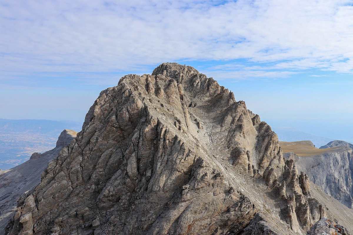
Mountains in Greece shape the mainland and the islands. Trips with a host run through these highlands, from Macedonia to Crete. Topics run from Olympus, the Pindus, Smolikas, Kaimakchalan, Tymfi, Vardousia, Parnassus and Mount Athos to island peaks. The list then moves on to Taygetus, Mount Ida and other summits of the Peloponnese and the islands. Related reading includes Greece hiking tours, national parks in Greece and a Meteora tour from Athens. More trips appear among the Greece tours.
Bookings made through the GetYourGuide widgets on this page earn Classical Greece Tours a commission, at no extra cost to the traveller.
Which are the mountains in Greece?
The mountains in Greece include Olympus, which ranks seventh by height among the mountains of mainland Europe. By prominence, Mount Olympus stands ninth on that same European list. Prominence measures how far a summit rises above the lower land around it.
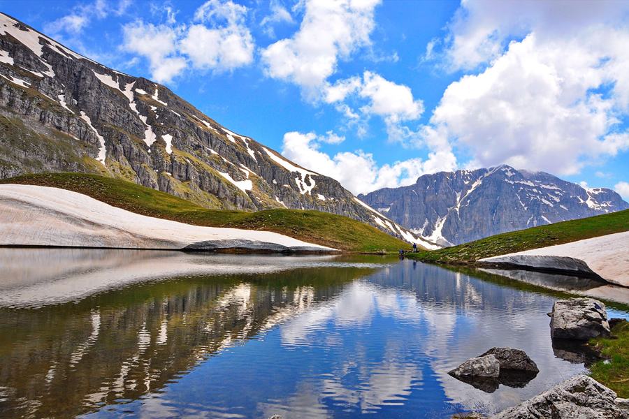
The Pindus chain does not end on the mainland. Its extensions run underwater across the Aegean Sea, and they join the Taurus Mountains of southern Turkey. Central and western Greece hold high and steep peaks. In these regions, the mountains in Greece are crossed by canyons in great number. Canyons are deep, narrow clefts with sheer rock sides.
Mount Giona stands as the highest mountain anywhere to the south of Olympus. It also ranks fifth among the mountains in Greece. In classical antiquity, the time of Greek and Roman civilisation, the mountain bore another name, Aselinon Oros. Those two old Greek words together mean the moonless mountain.
Giona’s tallest summit is Pyramida, which climbs to a height of 2,510 metres. Giona sits between three other mountains, each on a different side. Parnassus rises to the east of it, and Oeta lies to the north. Vardousia completes this group of neighbours on the western side.
- Other peaks: Perdika reaches 2,484 metres and Tragonoros 2,456 metres among the further summits of Giona.
- Gramos: Gramos is a mountain chain that runs along the border of Albania and Greece.
- Height: Part of the northern Pindus, Gramos reaches 2,523 metres at its highest peak.
Snow can appear in every part of Greece. It stays rare across the archipelago, or chain of Greek islands. On low ground, fallen snow rarely lasts longer than a single day. On the tops of the highest mountains in Greece, snow lasts well into the summer months.
What shapes the summit of Olympus among the mountains in Greece?
The mountains in Greece include Olympus, whose skyline above the town of Litochoro forms a clear V. Two peaks of almost equal height make up its two arms. The left arm is Mytikas, also called Pantheon, while Stefani forms the right arm.
On the eastern side of the high peaks, the steep slopes form parallel folds. Locally, these long bands carry the name Zonaria. Even narrower and steeper grooves, known as the Loukia, climb toward the summit. The mountain also holds precipices and a number of caves that are still unexplored today.
Almost in the centre of the mountain lies Bara, alpine tundra at 2,350 metres. Alpine tundra means the treeless zone of high mountain ground. In places, the wind heaps up drifts of snow between 8 and 10 metres deep. Greeks call these drifts anemosouria. In deep ravines, the snow stays on the mountain through the whole year.
In the 1960s, the highest weather station among the mountains in Greece stood on Agios Antonios. Average yearly rain and snow reach 149 centimetres at Prionia and 170 centimetres at Agios Antonios. The coastal northeast slopes catch more rain than the inland northwest, so their plant cover grows thicker.
- Botany: The study of plants on the tallest of the mountains in Greece began in 1836 with Aucher-Eloy.
- Explorers: Leon Heuzey came in 1855 and Heinrich Barth in 1862 to study the mountain.
- Name: The origin of the name Olympos remains unknown to this day.
Among the mountains in Greece, Olympus holds a large number of smooth peaks above 2,000 metres. Deep gorges cut between these smooth summits. Kalogeros reaches 2,700 metres, Toumpa 2,801 metres and Profitis Ilias 2,803 metres.
How far do the Pindus mountains in Greece stretch?
The mountains in Greece of the Pindus range begin near the border with Albania. From there the chain enters Epirus and Macedonia in the north. It then runs southward through the mainland as far as the area north of the Peloponnese.
The ancient Greeks gave the name Pindos to the mountainous region at the very heart of the range. Mountain villages with long histories and their own style of building stand across the whole chain. In recent decades, villages such as Metsovo have grown into resorts with ski facilities.
Two major forest zones grow on these mountains in Greece, because their heights vary so widely. In the valleys and canyons, at middle and lower heights, mixed broadleaf woods take over. Broadleaf trees carry wide, flat leaves rather than needles. Bosnian pine grows in the higher parts of Pindus National Park. The park shelters bears, wild cats and lynxes.
Over the centuries, the forests here have faced overgrazing, farming and clearing. On the steep, unstable soil, road-building and clear-cutting, or felling whole stands of trees, have caused landslides. Bauxite mining, for the ore of aluminium, also threatens the variety of life in these mountains in Greece. Heavy collecting of wild plants adds to that pressure.
- Gorges: The Vikos Gorge and the Aoos Gorge, two notable gorges of Europe, lie in the area.
- Coins: Pindus National Park was the main motif for two collectors’ coins minted in 2007.
- Threat today: The greatest threats to these forests now come from mountain tourism and ski resorts.
Between 1682 and 1689, Anastasios Gordios turned an older praise of Saint Vissarion into everyday Greek. Pahomios Rousanos had first drafted that praise in 1552. His text says these mountains in Greece divide the Ioannina region from the Thessaloniki region.
Where does Smolikas rank among the mountains in Greece?
The mountains in Greece have their second highest summit on Smolikas. Only Mount Olympus stands taller than it. Smolikas rises in the Ioannina regional unit of far northwestern Greece. Its slopes lie wholly inside the municipality of Konitsa, a local area of government.
Among the mountains in Greece, Smolikas is one built of ophiolite rocks. Ophiolite means a slice of ocean crust and of the upper mantle, the layer just under it. Such a slice was lifted up and exposed. Its name holds the Greek word ophis, meaning snake, after the surface texture of certain examples.
During the Pleistocene ice age, glaciers filled the bowl-shaped hollows and valleys on the northern and eastern sides. The river Vjosa drains the mountain to the south. To the north runs the Vourkopotamo, which feeds the Sarantaporos. Two more mountains in Greece flank it: Vasilitsa to the southeast and Voio to the northeast.
Above 2,000 metres, the slopes turn to grassland and bare rock. Lower down, forests of deciduous trees and conifers take over. Deciduous trees drop their leaves each autumn, while conifers carry needles and cones. The town of Konitsa stands 15 kilometres to the southwest of the summit.
- Villages: Agia Paraskevi stands to the north, with Palaioselli, Pades and Armata on the southern side.
- Rock colour: Among ophiolite rocks, certain examples show a clear green colour.
- Rock origin: The origin of ophiolites stayed uncertain until the theory of moving crustal plates appeared.
Among the mountains in Greece, Smolikas held glaciers until around 11,500 years ago. At that time, the very last glaciers of the whole area retreated. In Aromanian, a language spoken in the Balkans, the mountain carries the name Smolcu.
What story does Kaimakchalan add to the mountains in Greece?
The mountains in Greece meet North Macedonia on Kaimakchalan. This peak sits right on the line dividing the two countries. The frontier runs straight across its summit. Within Greece, only Mytikas and Smolikas stand higher, so it holds third place.
Kaimakchalan, at 2,521 metres, crowns the Voras range among the mountains in Greece. In North Macedonia, it ranks fifth among the peaks of the country. Its name comes from Ottoman Turkish, once the official tongue of the Ottoman Empire. The white, snowy look of the summit inspired that name.
During the First World War, Serbian and Bulgarian troops fought the Battle of Kaymakchalan on the Macedonian front. The fighting lasted from 12 September to 30 September 1916. From 26 to 30 September, control of the peak passed back and forth between the sides. The Serbian army finally took it on the 30th.
The approach of winter then made further fighting almost impossible. In 1928, the soldiers’ monument on the peak became a church and ossuary of Saint Peter. An ossuary is a building where human bones are kept. A year later, the heart of Archibald Reiss was laid there in an urn, as he had asked.
- Reiss: Archibald Reiss was a Swiss journalist who reported on the battles of the Macedonian front.
- Monument: North Macedonia has declared the church on the peak a cultural monument of the country.
- Peak name: The highest point of these mountains in Greece also carries the name Prophet Elijah.
The battle proved very costly for both of the armies that fought on the mountain. Among the mountains in Greece, Kaimakchalan has a subarctic climate. Its summers stay short and cool, while its winters stretch long and stay cold.
Which peaks and creatures give Tymfi its place among the mountains in Greece?
The mountains in Greece of the northern Pindus range include Tymfi, in the northwest of the country. Tymfi forms a massif, a large block of linked peaks. Gamila, its tallest summit, reaches 2,497 metres above the sea.
The peak names come mainly from Greek. Megala Litharia means big rocks in modern Greek. Tsouka Rossa, by contrast, comes from Aromanian, a Balkan language, where it means red peak. The mountain’s own name dates back to ancient times. Even so, no Greek or foreign geographer of the 19th century used it to describe the area.
The mountain runs about 20 to 25 kilometres from east to west. Its width, measured north to south, is about 15 kilometres. Its southern and southeastern slopes are fairly smooth. Up high, the peaks join into a plateau, a stretch of raised, level ground. Astraka dominates the plateau on its northern face.
Glacial deposits on Tymfi descend as low as 850 metres. They include rock glaciers and limestone pavements, wide flat sheets of bare, cracked limestone. Of all the mountains in Greece, Tymfi has the biggest recorded population of Balkan chamois. Between 120 and 130 of these wild goats live there, out of 477 to 750 nationwide.
- Birds: The Egyptian vulture, short-toed snake eagle and rufous-tailed rock thrush breed here among the mountains in Greece.
- River source: The Voidomatis river, a tributary of the Aoos, rises from springs inside the mountain.
- Local name: The former municipality of Tymfi took its name from the mountain.
Among the mountains in Greece, Tymfi lies largely inside the Vikos-Aoos National Park. Only its southernmost part, around the peak of Astraka, stays outside it. The national park receives more than 100,000 visitors in a single year.
What lives on Vardousia, one of the mountains in Greece?
The mountains in Greece include Vardousia, a range split into three main parts. Northern Vardousia forms the first part, and its highest peak, Sinani, reaches 2,059 metres. Southern Vardousia holds the top summit of the whole range, Korakas.
Four other mountains in Greece stand around Vardousia. The Panaitoliko mountains lie to its west, and Tymfristos rises to the northwest. Oeta stands to the east. Giona completes the ring to the southeast. The municipal unit of Vardousia, named after the mountain, covers its western part. Such units are divisions within a larger municipality.
Mediterranean maquis, a thick kind of shrubland, covers the lowest slopes of the range. Higher up, mixed forests of oak, elm and sweet chestnut take over. Above 1,700 metres, the plant life turns to alpine vegetation. Alpine vegetation means the low, hardy plants of high mountain ground.
Until recently, bearded vultures and griffon vultures also lived in the area. Vultures are big birds that eat the flesh of animals already dead. On the alpine meadows and peaks of these mountains in Greece, horned larks and white-winged snowfinches live. Other notable birds include rock partridges, black woodpeckers and alpine swifts.
- Endemic plants: Achillea barbeyana and Alyssum nebrodense rank among the notable endemic plants, restricted to a small area.
- Rare plants: Astragalus hellenicus, Cirsium heldreichii and Fritillaria thessala grow among the rare plants of Vardousia.
- Reptiles: Hermann’s tortoises, Balkan green lizards and the long-nosed viper live on the mountain.
The municipal unit of Lidoriki covers the southern part of Vardousia. Its villages there include Dafnos, Diakopi, Kallio and Koniakos. Among the mountains in Greece, Vardousia also has the village of Athanasios Diakos on its eastern side. Anatoli and Dafni lie to the north.
Which myths and poets belong to Parnassus among the mountains in Greece?
The mountains in Greece count Parnassus among the largest mountain regions of the mainland. It also ranks among the highest Greek peaks. To the east, the mountain ends at the valley of the Boeotian Cephissus. The valley of Amfissa bounds it on the west.
The mountain is made of limestone. Winters there are very cold, and summers stay cool. Mycenaean settlements stood in great number south and east of the mountain. Yet the name Parnassos does not appear in their language as known from Linear B script. Linear B is the script the Mycenaeans used to write early Greek.
On Parnassus, Orpheus received a little golden lyre from the god Apollo. Apollo also showed him how to play it. With its strings on a frame, the lyre works like a small harp. Orestes, too, spent a period in hiding on Parnassus. Among the mountains in Greece, it was also sacred to the god Dionysus.
Parnassus gave its name to Parnassism, a poetry movement founded in France between 1866 and 1876. It arose as a reaction to Romanticism. The Parnassists never numbered more than twenty poets. Their belief in art for its own sake came first from Theophile Gautier. Parnassism also shaped modern Greek poets such as Kostis Palamas and Ioannis Gryparis.
- Periodical: Catul Mendes and Xavier Ricard issued the journal Modern Parnassus, which named the mountain directly.
- Satire: In The Battle of the Books, from 1697, Jonathan Swift set a war of ideas on Parnassus.
- Ski runs: The ski centre on these mountains in Greece has 25 marked runs, the longest stretching 4 kilometres.
The Parnassists took their name from one of the mountains in Greece. The group held strong sway over the cultural life of Paris. They owed that influence to their careful work on rhyme and vocabulary. Their poems returned to certain classical elements.
What sets Mount Athos apart from the other mountains in Greece?
The mountains in Greece include Mount Athos, called Oros Athos in modern Greek. Other Orthodox languages, such as Bulgarian, Macedonian and Serbian, name it Sveta Gora, which means Holy Mountain. In Russian, Ukrainian and Belarusian, the name is simply Afon.
A Spartan fleet of 50 ships under Epicleas was lost off this coast in 411 BC. The city of Eretria founded colonies on the peninsula, then called Akte. A colony was a fresh settlement planted by people from a parent city. Certain of these towns minted their own coins.
Mixed forests of broadleaf deciduous and evergreen trees cover much of the mountain. Deciduous trees lose their leaves each year, while evergreens keep them. Aleppo pine turns up more widely toward the north of the peninsula. Among the mountains in Greece, Athos lends its name to two plants, Isatis tinctoria athoa and Viola athois.
Birds on this peak among the mountains in Greece include golden eagles and black storks. The lesser kestrel, the western capercaillie, Audouin’s gull and the yelkouan shearwater also join the list. Among the mammals, roe deer, hares and red squirrels live on the slopes too. Swallows, nightingales and hoopoes also appear among the birds.
- Old temple: Hesychius wrote that Zeus Athonite still had a temple and a statue there in the fifth century.
- Pliny: In 77 AD, Pliny the Elder claimed that people on Athos ate viper skin and lived 400 years.
- Revival: Gifts from Russia, Serbia and Romania funded a monastic revival on Athos during the 19th century.
Among the mountains in Greece, Athos also holds plants that grow from tubers and bulbs. They include crocus, anemone, cyclamen and fritillary species. A bulb is a round underground store of food from which a plant sprouts again each year.
Where does Taygetus stand among the mountains in Greece?
Mountains in Greece take in Taygetus, a range on the Peloponnese about 100 km long. It stretches from the centre of the peninsula down to Cape Matapan, its southern tip. Its summit, Profitis Ilias, rises to 2,405 m, the tallest point in the Peloponnese.
Of the names of mountains in Greece, Taygetus ranks among the oldest recorded in Europe. The Odyssey, an ancient epic, names it. The mountain forms a limestone horst. A horst is a raised block of land between faults, or deep breaks in the rock. It borders the Eurotas Rift Valley, a sunken strip of land.
The northern range holds part of the Eurotas river’s headwaters. Headwaters means the first streams that feed a river. On the western side, the Vyros Gorge carries winter snowmelt down the mountain. Its waters empty into the Messenian Gulf at the town of Kardamyli. A gorge is a narrow valley hemmed in by rock walls.
Taygetus is one of the mountains in Greece with heavily forested slopes. Greek fir and black pine are the main trees there. The summit, Profitis Ilias, honours the Prophet Elias every 20 July, his feast day. On that date, the small chapel at the peak holds a large festival with a massive bonfire.
- Saggias: The stretch of Taygetus that runs down the Mani Peninsula as its backbone also goes by Saggias.
- Charisia: Each spring in ancient times, women wore a mountain plant, Charisia, tied at the neck.
- Two cities: Taygetus overlooks the cities of Sparta and Kalamata and dominates their skyline.
Among the mountains in Greece, Taygetus sheltered the native population during the era of barbarian invasions. Native means the people who already lived in the region. Barbarian was an old Greek word for foreign peoples. An invasion means foreign forces breaking into a land.
Why does Mount Ida head the list of mountains in Greece on Crete?
Mountains in Greece reach their Cretan high point on Mount Ida, at 2,456 metres. No other summit on the island rises higher. The massif that holds the mountain is called Psiloritis. A massif means a tight cluster of linked peaks.
Psiloritis joins Greek words for high and mountain, giving tall mountain. In the myths told about mountains in Greece, Ida belonged to the Titaness Rhea as a holy place. A Titaness was a female Titan, one of the older gods of Greek legend. By Greek times, the Idaean Cave on the mountain was rededicated to Zeus.
The Idaean cave, like the Dictaean one, served for initiations. Initiations were rites that brought newcomers into a secret cult. The cave possibly served as an oracle, a place where people asked a god for answers. A tripod, or three-legged stand, appears again and again on coins from nearby Axos as its sign.
Within the mountains in Greece, Psiloritis lies on the water divide of Crete. On a water divide, rain runs off in two opposite directions. The southern part of the island drains to the Libyan Sea. The northern basin faces the Aegean Sea instead. To the west, the ridge continues with Mount Stolistra, at 2,336 m.
- Rivers of Hell: Dante’s old man inside Mount Ida weeps tears that form the Acheron, Styx and Lethe.
- Mixed myths: Apollonius of Rhodes seemingly placed the childhood of Zeus at both Dikte and Ida.
- Food plants: A study at the Minoan villa of Zominthos found a rich range of nourishing food plants.
The name of the mountain appears in other spellings too, such as Idha, Idi and Ita. Spellings are the letter forms used to write a word. All these forms name one summit, the highest of the mountains in Greece on Crete.
What caves and plateaus give the White Mountains a place among the mountains in Greece?
Mountains in Greece include the Lefka Ori on Crete, a name meaning White Mountains. This range covers part of Western Crete, within the Chania prefecture, a local district. Its highest summit, Pachnes, stands at 2,453 m above the sea.
Limestone forms the bulk of the range, its shades running from pale grey through bluish to black. Limestone builds up over ages from the shells of tiny sea animals. Pachnes is the second tallest peak on Crete, after Mount Ida. Across the mountains in Greece, Pachnes ranks 10th in height.
Gourgouthakas is a cave inside the Lefka Ori range, part of the mountains in Greece. Its name means a small rock hollow where rain collects for animals to drink. Until a new survey in 2022, it counted as the deepest cave in Greece, at 1,208 metres. The new survey set the depth at 1,100 metres instead.
The Omalos Plateau lies in the White Mountains, and its village sits 38 km south of Chania. A plateau is a raised area of flat land. Its name comes from a Greek word meaning even, plain or smooth. The plateau covers 15 square kilometres. It began as a lake that, by one view, drained away through the Tzani Cave.
- Throne of Zeus: Legend links the peaks of Gingilos and Volakias, rising at Xyloskalo, with the throne of Zeus.
- Pastures: In the warmer seasons, shepherds bring their flocks to pastures called madares on the slopes.
- Plateau crops: Omalos has a cool climate and fertile soil for potatoes, apples and cereals.
On the map of mountains in Greece, the Tzani Cave sits about 1.6 km from Omalos. Its length reaches about 2.5 km, and it drops 241 metres. It is in fact a covered gorge, a narrow ravine under a roof of rock.
Which myths tie Dikti to the mountains in Greece?
Mountains in Greece rise in eastern Crete as Dikti, a range in the regional unit of Lasithi. That term marks one level of local government in Greece. On its western side, the range reaches into the regional unit of Heraklion.
One story about mountains in Greece comes from Apollodorus, a writer of myths in the 2nd century AD. In his account, Zeus was born to Rhea in a cave of Mount Dikte. Two nymphs then raised the infant, feeding him goat’s milk from Amalthea. Nymphs were nature spirits. Modern scholars broadly agree that Dikte lay in eastern Crete.
Britomartis was a Greek goddess linked with mountains, hunting and nets, worshipped above all on Crete. Cretan coins frequently portrayed her as Diktynna, the goddess of Mount Dikte. On those coins, Diktynna appears as a winged goddess with a human face. She stands on top of the mountain, holding an animal in each hand.
Among the plateaus of the mountains in Greece, Katharo sits on the Dikti mountain. It lies at an average height of 1,150 m. That is 300 m higher than the Lasithi Plateau. Because of this height, no one lives there in winter. In summer it has about 500 inhabitants, mainly shepherds.
- Lazaros: West of Katharo rises the peak of Lazaros, which reaches 2,085 metres.
- Forests: Pines, Kermes oaks, cypresses, holm oaks and Cretan maples cover large parts of Dikti.
- Havgas gorge: Water from Katharo drains through the Havgas gorge into the larger, lower Lasithi Plateau.
In this corner of the mountains in Greece, Dikti’s dominant feature is the Lasithi Plateau. No plateau on Crete is larger. Across the range, the fertile valleys and plateaus matter greatly to the local economy. Fertile land is soil rich enough to grow good crops.
How does Mount Zas top the Cyclades among the mountains in Greece?
Mountains in Greece reach the island of Naxos with Mount Zas, which is also called Mount Zeus. Its summit stands 1,001 m above sea level. That height makes it the highest peak in the Cyclades, a group of Aegean islands.
On this island peak of the mountains in Greece, the name Zas shares its root with Zeus. Words with a shared root are called cognates. Agathosthenes wrote a history of Naxos. In his telling, Zeus spent his childhood in the cave on this mountain. He hid there from his father, Cronus.
Zeus’s cave lies about 628 m up the western slope of the mountain. Its use stretched from the Late Neolithic up to Early Cycladic III times. The word Neolithic names the New Stone Age, the final stage of that era. Early Cycladic is the name for the first Bronze Age culture of these islands.
Inside this cave in the mountains in Greece, no remains of crop processing have been found. Archaeologists suggest it was no year-round home. They think herders kept animals there through the driest months. Digs in the cave ran in 1985-1986, with a further season in 1994. A dig is an excavation, the careful uncovering of old remains.
- Cave formations: Large stalactites and stalagmites, rock columns made by dripping water, have been found inside.
- Zeus Melosios: An ancient rock carving near the cave calls Zeus the protector of the sheep.
- Filoti: The cave sits to the southeast of Filoti, which stands where the slopes begin.
In the mountains in Greece around Filoti, free-range sheep and goats are the main produce. Free-range animals graze outdoors instead of in sheds. Local dairy products include kefalotyri and mizithra, both Greek cheeses. Kefalotyri is a hard, salty cheese, and mizithra is a soft whey cheese.
What gives Fengari its moon name among the mountains in Greece?
Mountains in Greece reach an elevation of 1,611 metres on the Aegean island of Samothrace. Elevation is the height of land above sea level. That height belongs to Fengari, the tallest mountain on the island. Its current common name, Fengari, means moon.
In a legend of the mountains in Greece, Poseidon watched the Trojan War from Fengari’s peak. Poseidon ruled the sea in Greek belief. The Trojan War was the Greek war against Troy in epic poems. A local legend centres on the summit. In it, anyone at the top on a full-moon night sees a wish come true.
Thanks to its height and varied climate, Fengari holds rare and interesting plant species. The mountains in Greece hold endemic plants, and Fengari has its own. An endemic plant grows wild in just one area. Herniaria degenii and Potentilla geoides are two of them. Climate is the usual pattern of weather in a place.
Fengari also supports a very rich and diverse range of bird life. Diverse means made up of different kinds. The mountain stands on Samothrace, which ranks among the roughest Greek islands. Rough, or rugged, land is broken, rocky and uneven. The greater part of the island is too mountainous for farming.
- Saos: Samothrace has Mount Saos, and Fengari is the highest peak of that mountain.
- No harbours: Samothrace lacks natural harbours, so it never became a state of political weight in ancient Greece.
- Sea marker: In classical antiquity, sailors found the mountain very useful for navigation, thanks to its height.
Samothrace, home to this peak of the mountains in Greece, has granite and basalt among its resources. Granite is a hard, speckled rock formed underground from cooled magma, or melted rock. Basalt is a dark rock made from cooled lava.
How do rivers and a telescope mark Chelmos in the mountains in Greece?
Mountains in Greece include Aroania, a mountain in Achaea, Peloponnese, also known as Helmos or Chelmos. It sits in the south-east of Achaea, near the border with Corinthia. No other mountain in Achaea rises higher than this summit.
Chelmos derives from chlmo, a South Slavic word for summit. South Slavic is a group of languages of the Balkans. Aroania holds a string of high peaks among the mountains in Greece. Neraidorachi reaches 2341 m, Aetorachi 2335 m and Kokkinovrachos 2315 m. Peaks are the sharp high points of a range.
The slightly higher Kyllini stands about 15 km east of Aroania. The valley of the river Olvios separates the two mountains. About 30 km to the west stands Erymanthos, another of the mountains in Greece. The valley of the river Vouraikos lies between them. Valleys are long stretches of low ground between heights.
Rivers carry water off the mountain in two directions. The Krios, Krathis and Vouraikos carry water north into the Gulf of Corinth. Gulf is the name for a broad inlet of sea. The river Aroanios runs the other way, towards the southwest. It drains the slopes towards the Ionian Sea.
- Telescope: Aristarchos, a telescope for viewing distant stars, has its home on this mountain.
- Chelmos blue: This butterfly is found at heights from 1,100 m up to 1,800 m.
- Villages: Planitero and Peristera are the mountain villages that stand on Aroania.
Here in the mountains in Greece, pine forests cover Aroania from 800 m to 1,800 m. Higher up, open grasslands and barren rock take over. Grasslands are open areas of wild grass with hardly any trees. Barren rock is bare stone where almost nothing grows.
What do travellers ask about Mountains in Greece, and what are the answers?
Mountains in Greece also include Mount Kyllini, north of Tripoli in the Peloponnese. Kerkis forms the bulk of western Samos. Mount Pantokrator rises in north-eastern Corfu. No mountain on Rhodes stands higher than Attavyros, in the Dodecanese island group.
Which god was born on Mount Kyllini, one of the mountains in Greece?
Greek myth places the birth of Hermes in a sacred cave on Mount Kyllini. Cyllenius, from the mountain, became a frequent epithet of his. An epithet is a descriptive extra name. The travel writer Pausanias said Kyllenos, son of Elatos, named the mountain. He put the height of its Hermes statue at about eight feet.
What gives Kerkis on Samos its colour and name among the mountains in Greece?
Kerkis looks whitish because it is made of marble. Its name, in ancient and modern forms, roughly means belonging to Circe. Circe was a sorceress in Greek myth. Pythagoras is said to have hidden from the tyrant Polycrates in a cave on its eastern slope. Tyrant then meant a sole ruler who seized power.
Which buildings stand on Mount Pantokrator in the mountains in Greece?
The first summit monastery, an Angevin building of 1347, was destroyed about 1537. Angevin refers to a ruling house from Anjou, in France. The present church dates from around 1689, and its facade from the 19th century. A facade is a building’s outer front. Its dedication honours the Transfiguration of Christ.
Why did a myth place an altar on Attavyros among the mountains in Greece?
In myth, Althaemenes raised an altar here to Zeus Atabyrios. An altar is a raised place for offerings. He reportedly picked it as the only point on Rhodes from which his homeland, Crete, was visible. Close to the summit, ruins of that sanctuary survive. Sanctuary here means a holy precinct where a god was honoured.