Volcanoes in Greece line the South Aegean Volcanic Arc, from Sousaki near Corinth to Nisyros in the Dodecanese. Small-group trips through Greece run on these islands and on the mainland. Sections cover Sousaki, Milos, Antimilos, Santorini and the Minoan eruption. Others turn to Nea Kameni, Kolumbo, Nisyros, Gyali and the Lesvos Petrified Forest. Related pages cover a Santorini day trip from Athens, Milos tours and the Dodecanese islands. Wider trips are listed under Greece tours.
Bookings made through the GetYourGuide widgets on this page earn Classical Greece Tours a commission, at no extra cost to the traveller.
Which are the volcanoes in Greece?
The volcanoes in Greece belong to the South Aegean Volcanic Arc. Plate tectonics formed this curved chain across the southern Aegean Sea. Plate tectonics means the slow movement of huge slabs of the Earth’s crust. A volcanic arc is a bow-shaped string of volcanoes.
Its active part takes in Sousaki, Aegina, Methana, Milos, Santorini, Kolumbo, Kos, Nisyros and Yali. Of these volcanoes in Greece, only three have erupted or shown real unrest in the past 100 years. They are Santorini, Kolumbo and Nisyros. Unrest means signs that a volcano is stirring, such as earthquakes or fresh gas.
The arc began with the African plate sinking beneath the Eurasian plate. A plate is one of the giant rigid pieces of the Earth’s surface, and this sinking is subduction. Magma, which is melted rock from deep below, later broke through thinned crust. It built a second arc, made of a chain of volcanoes in Greece and beyond.
The southern Aegean ranks among the parts of the Himalayan-Alpine mountain belt that change shape fastest. That belt is the long line of young mountains from the Alps to the Himalayas. The Hellenic arc is one of the busiest seismic zones in western Eurasia. Seismic means linked to earthquakes. Eurasia is Europe and Asia taken together.
- Length: The arc holding the volcanoes in Greece stretches roughly 450 km and spans 20 to 40 km.
- Ends: It runs from the Isthmus of Corinth, a narrow neck of land, to the Bodrum peninsula in Turkey.
- Change: The stretching of the Aegean crust that shaped this arc is still going on today.
North of the Hellenic arc lies an older inner arc, a legacy of the Alpine Orogeny. An orogeny is a long era of mountain building, when rock is folded and pushed up into ranges. The Cyclades are the tops of that inner arc.
Where does Sousaki sit among the volcanoes in Greece?
The volcanoes in Greece include Sousaki, a dormant volcano in northeastern Corinthia. Dormant means quiet but not dead. Sousaki is also a modern solfatara field. A solfatara is a place where hot volcanic gases, rich in sulphur, seep out of the ground.
Sousaki stayed active through the Pliocene and into the early Quaternary. The Pliocene is a span of the Earth’s past just before the ice ages. The Quaternary followed it and still runs today. In those periods the volcano erupted dacite lava. Dacite is a pale volcanic rock rich in silica, the mineral of sand and glass.
Significant solfataric activity still goes on at the site. The geothermal system gives off about 1 megagram of gas each day, at 42 °C. Geothermal means heated from deep inside the Earth. A megagram equals one tonne. The gas is 90% carbon dioxide. Carbon dioxide is the gas that people breathe out.
Earthquakes of magnitude 3 to 4 struck the area in 1997. Magnitude is a number for how strong an earthquake is. Those shocks pushed magma, or molten rock, higher into the crust. The crust is the solid outer layer of the Earth. So future activity is possible at this dormant site among the volcanoes in Greece.
- Arc: Of the volcanoes in Greece along the South Aegean Volcanic Arc, Sousaki sits at the northwest end.
- Gases: Methane and hydrogen sulphide each make up under 1% of the gas at Sousaki.
- Coast: Major port and refinery facilities stand today on the shores of the Gulf of Megara.
Among the volcanoes in Greece, Sousaki last erupted from its side. A side eruption bursts from the side of a volcano rather than from its summit. This outburst created new land in the waters of the Gulf of Megara.
What makes Milos one of the volcanoes in Greece?
The volcanoes in Greece count Milos as a dormant member, one that can erupt again in the future. Its volcano last erupted 90,000 years ago, during the Pleistocene. The Pleistocene is the long age of the great ice sheets on Earth.
Among the volcanoes in Greece, Milos lies 120 km due east of the Laconia coast. Laconia is the region of Sparta in the southern Peloponnese. The main harbour sinks from 70 to 30 fathoms deep, or from 130 to 55 m. A fathom is an old sea measure of about six feet, used for water depth.
The greater portion of Milos is rugged and hilly. Rugged means rough and broken, with steep rocky slopes. The mining of obsidian, a glassy volcanic rock, never led to permanent homes or workshops on the island. One cave lies on the south coast of Milos. Inside that cave, volcanic heat remains strong even now.
On Milos, one of the volcanoes in Greece, hot sulphurous springs rise on the harbour’s eastern shore. Sulphurous means rich in sulphur, a yellow mineral. In ancient times the alum of Milos ranked next to that of Egypt. Alum is a mineral salt once used to fix dyes in cloth.
- Mining: In the past, baryte, a heavy white mineral, was mined on Milos with sulphur, millstones and gypsum.
- Obsidian: Obsidian from Milos was already traded as a commodity 15,000 years ago.
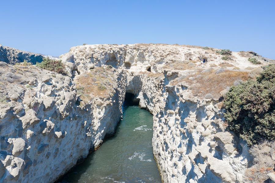
- Firiplaka: Towering cliffs from one of the volcanoes in Greece rise above Firiplaka beach on southern Milos.
From east to west Milos measures about 23 km, and from north to south 13 km. Its land area is put at 151 square kilometres, close to 58 square miles. A mile is an old unit of distance still used in Britain.
Why does Antimilos count among the volcanoes in Greece?
The volcanoes in Greece take in Antimilos, a volcanic island in the Cyclades. Its crater, the bowl at the volcano’s top, is still plain to see. It lies 21 kilometres northwest of Milos. The name Cyclades comes from the circle the islands form around Delos.
Antimilos is a lump of trachyte with no residents, and it climbs to 671 m. Trachyte is a grey volcanic rock with a rough feel. Trachys, the Greek word for rough, gave it its name. For local government, Antimilos comes under the municipality of Milos. Municipalities are local districts, each run by councillors chosen by voters.
Ancient islanders used the crater as an open store for rainwater. A rain store keeps water for later use. On this member of the volcanoes in Greece, wall remains and obsidian arrowheads point to prehistoric settlement. Arrowheads are the sharp tips fixed to arrows. Prehistoric means before written records.
A rare goat, Capra aegagrus pictus, lives on this outpost of the volcanoes in Greece. The Latin name marks it as a form of the wild goat. It is similar to the Cretan kri-kri, but it is not the same animal. The kri-kri is the wild goat of Crete, known for its long curved horns.
- Lookout: From the highest point of Antimilos, people were able to watch the sea over long distances.
- Cistern: Remains of a cistern, a stone water store, point to Roman or early Christian builders.
- Name: Among the volcanoes in Greece, Antimilos also goes by Erimomilos, which means Desert Milos.
One reading of the Odyssey places the island of the sun god Helios here. In that tale, the companions of Odysseus killed the sacred cattle of Helios. The Odyssey is the ancient Greek poem that follows Odysseus on his journey back from Troy.
How did Santorini grow into one of the volcanoes in Greece?
The volcanoes in Greece have a long record on Santorini. The region first became volcanically active about 3 to 4 million years ago. Volcanism on Thera itself began about 2 million years ago. Dacitic lavas then poured from vents near Akrotiri.
Thera rests on a small non-volcanic basement, the older bedrock beneath its lavas. That basement was once a separate island of roughly 9 by 6 km. Metamorphosed limestone and schist make up the bulk of it. Metamorphosed rock has been reshaped by fierce heat and squeezing far below ground. Schist is a flaky stone that peels apart in sheets.
Early eruptions, a share of them undersea, struck the Akrotiri Peninsula. Their dates span 650,000 down to 550,000 years before now. Over the past 360,000 years, two major cycles have shaped this member of the volcanoes in Greece. Each cycle closed with a pair of caldera-forming eruptions, which leave a huge pit called a caldera.
The cycles end when the magma turns rhyolitic, which brings the strongest explosive eruptions. Rhyolitic magma is thick and full of silica, so gas builds up inside it. The Kameni islands are the newest cone that this volcano has built. Much of that cone lies hidden under the water of the caldera.
- Water: Ancient Akrotiri, beside one of the volcanoes in Greece, piped hot water that appears geothermal.
- Dyke: A recent earthquake swarm matched a 30 km sheet of magma pushed into the crust under the Aegean.
- Pattern: The island grew through repeated rounds of shield volcano building, each followed by caldera collapse.
On Santorini, one of the volcanoes in Greece, the inner coast around the caldera is a sheer wall. It shows layer upon layer of solidified lava. A shield volcano is a broad, gently sloping cone built by runny lava.
How far did the Minoan eruption reach beyond the volcanoes in Greece?
The volcanoes in Greece spread the ash and pumice of the Minoan eruption across the island of Crete. There, people sometimes collected the fallen material and stored it. Pumice is a light, frothy volcanic rock full of tiny gas holes.
That ash on Crete came from an early phase of the eruption. It fell weeks or even months before the main phases began. Later on, tsunamis 9 metres high swept over coastal sites such as Palaikastro. Tsunami, a Japanese word, names a giant wave set off by a quake or eruption.
In 1987 scientists linked this eruption of the volcanoes in Greece to a sulphate spike in Greenland ice. The spike dated to 1644 BC, give or take 20 years. A sulphate spike is a sharp rise in sulphur compounds left by big eruptions. Later studies matched that layer’s ash to Mount Aniakchak, ruling out the Minoan eruption.
In Turkey, a cave stalagmite records peaks of bromine at 1621 BC, give or take 25 years. A stalagmite is a stone spike built up from a cave floor by dripping water. Bromine is an element present in volcanic gas. Survivors later returned to Akrotiri, a town on one of the volcanoes in Greece, to recover their goods.
- Myth: The eruption and its fallout are thought to have inspired the Titanomachy, the war of gods and Titans.
- Lightning: Writers compare the thunderbolts of Zeus in Hesiod’s poem on the gods with volcanic lightning.
- Scale: Among the volcanoes in Greece, the Minoan eruption compares with Tambora in 1815 and Samalas in 1257.
Santorini ash was once claimed in the Nile Delta. That claim is now known to be a misidentification, an error in naming a find. A delta is the fan of land that a river builds at its mouth. The Nile is the great river of Egypt.
Who was Ferdinand Fouqué in the study of the volcanoes in Greece?
The volcanoes in Greece drew Ferdinand André Fouqué, a French geologist and petrologist. A petrologist studies how rocks form and change. Fouqué analysed volcanic gases with the methods of Robert Bunsen. Santorini, among the volcanoes in Greece, was a notable site of that work.
In 1877 Fouqué became professor of natural history at the Collège de France in Paris. A professor holds the top teaching rank at a university or college. He was the first to bring modern petrographical methods into France. Petrography is the close description of rocks, made with a microscope and thin slices of stone.
His studies of the eruptive rocks of Santorini are singled out for special mention. Eruptive rocks are rocks that came out of a volcano. His chief works included Santorin et ses éruptions, published in 1879. The title means Santorini and its eruptions, so the book centres on one of the volcanoes in Greece.
In 1862 he uncovered a civilisation buried beneath pumice from one of the volcanoes in Greece. He made the find while doing geological digs on the island. Geological means linked to the study of rocks and the ground. A civilisation is a settled society with towns, crafts and trade.
- Walls: He found walls coated with stucco, a smooth plaster, and painted with stripes and floral designs.
- Pottery: His finds included both hand-made pottery and pots shaped on a potter’s wheel.
- Digs: Fouqué is also noteworthy for his archaeological excavations on the island of Santorini.
Fouqué was born at Mortain, in the Manche département of France. A département is a French administrative area, much like a county. In 1881 he was elected a member of the Academy of Sciences. That academy is the leading science society of France.
When did Nea Kameni rise among the volcanoes in Greece?
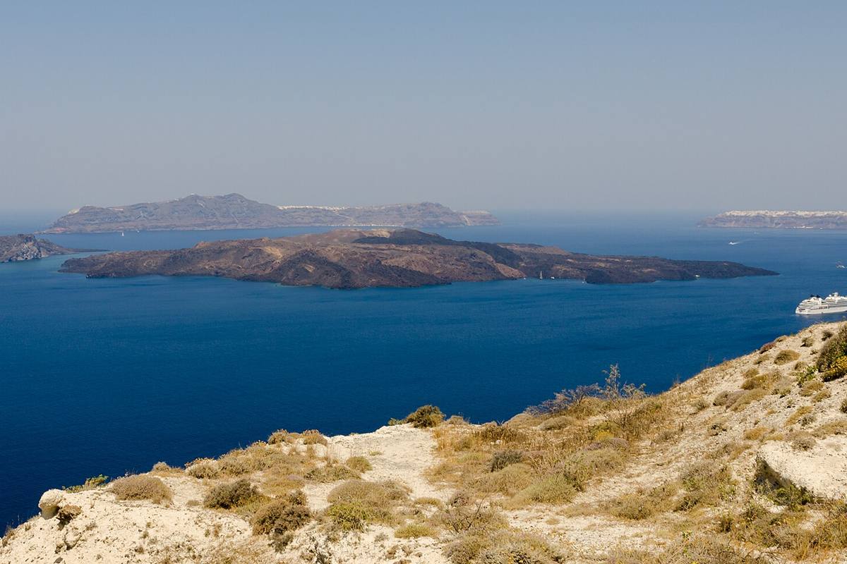
The volcanoes in Greece include the Kameni islands, where Santorini’s eruptions have centred since the Minoan blast. These islands lie in the centre of the Santorini lagoon. They are made of lava rock. Lagoon here names the sheltered water enclosed by the caldera’s islands.
Pliny the Elder, a Roman writer, reported a new island emerging on 8 July, 19 CE. CE marks years of the Common Era, the dating system in use today. In the 1570s the growth of Nea Kameni brought fresh reports of volcanic activity. Growth here means new land building up from repeated eruptions.
Scientists from ISMOSAV, the institute that studies and monitors the Santorini volcano, watch the island closely. Nea Kameni, one of the volcanoes in Greece, is a protected scientific site. Besides its current active crater, the island holds a number of former craters. Monitoring means checking a site again and again for change.
Nea Kameni has a large number of vents, openings where gas escapes from the ground. One active sulphur vent is named Jorgo, or George. Locals named this vent, on one of the volcanoes in Greece, after King George I. The vent became active one day after the king had come to Santorini.
- Fault line: The Kameni line, running southwest to northeast, has long been the main path for rising magma.
- Crater: A gravel path climbs to the top of the 130 metre volcanic crater on the island.
- Rim: A full circuit of the crater rim, the raised edge of the crater, is possible on foot.
Cassius Dio, a Roman historian, wrote about the birth of new land among the volcanoes in Greece. He recorded a small, unknown islet rising close to Thera in 47 CE. His report is thought to refer to Palea Kameni.
What hides under the waves at Kolumbo, among the volcanoes in Greece?
The volcanoes in Greece have a restless member at Kolumbo. Its magma chamber is gradually filling with melt. A magma chamber is a pool of molten rock below a volcano. Melt is its liquid part. Studies have tied the magma feeding Kolumbo to the Santorini volcano.
In 1650 a small ring of white pumice formed at this member of the volcanoes in Greece. Waves soon wore it away. The volcano then collapsed into its caldera and set off a tsunami. Collapsed here means the cone fell in on itself as the ground gave way. That wave damaged nearby islands up to 15 km away.
In 2006 a NOAA Ocean Explorer expedition studied the sea-floor deposits with ROV robots. NOAA is the United States agency for oceans and the air. An ROV is a remotely operated vehicle, steered from a ship. The team explored, sampled and mapped deposits left by two explosions in the Aegean.
The 2006 team also began new seismic air-gun techniques to map pumice and ash. An air gun fires bursts of compressed air, and the echoes reveal layers below the seabed. The sea-floor deposit of pumice and ash around Santorini has been studied since 1975. A deposit is a layer of material laid down over time.
- Bacteria: A thick bacterial community covers the field of hydrothermal vents on the crater floor.
- Chimneys: Vent chimneys on this undersea member of the volcanoes in Greece seem to have built up since 1650.
- Hydrothermal: Hydrothermal vents are cracks in the seabed that release water heated by magma below.
Scientists judge that an eruption at Kolumbo is not imminent. Imminent means about to happen at any moment. They still recommend real-time monitoring of this restless site among the volcanoes in Greece. Real-time means tracked live as events unfold.
How active is Nisyros among the volcanoes in Greece?
The volcanoes in Greece count four historical eruptions on Nisyros, and each scored 2 on the VEI. The VEI, or Volcanic Explosivity Index, rates the size of an eruption. Nisyros is a remnant of an old mountain chain that also took in Kos.
Almost all eruptions at this island among the volcanoes in Greece involved phreatic activity. A phreatic eruption happens when magma heats ground water or surface water. Ground water is water held underground in soil and cracks in rock. Magma’s heat, from 500 to 1,170 °C, turns the water to steam almost at once.
The result is a blast of steam, water, ash, rock and lumps called volcanic bombs. These bombs are blobs of lava that harden as they fly. Winds over the island can blow especially strong, because of jet effects as the air passes over Kos. A jet effect speeds up wind as it squeezes past high ground.
The island’s geothermal potential is put at no less than 50 MW. MW stands for megawatts, a unit of power. The latest plan was for a 20 to 25 MW geothermal plant. Nisyros itself needs only 1 to 2 MW. Planners judged it possible to send power on to Kos, Tilos, Kalymnos and Leros.
- Earthquakes: Among the volcanoes in Greece, Nisyros is one where earthquakes are frequent.
- Wealth: Deposits of perlite, a volcanic glass, and pumice on nearby Gyali provide much of Nisyros’s wealth.
- Vote: In 1997 Nisyros held a referendum, and 87% voted against the geothermal plans.
Homer, the early Greek poet, mentions Nisyros, one of the volcanoes in Greece, in the Iliad. The Iliad is his epic on the Trojan War, fought between the Greeks and Troy. An epic tells in verse of heroes and their deeds.
Which rocks make Gyali one of the volcanoes in Greece?
The volcanoes in Greece built Gyali from domes of rhyolitic obsidian lava and beds of pumice. Its name means glass, and it is also spelled Giali or Yali. Rhyolitic describes lava rich in silica, which cools into glassy rock. Gyali belongs to the municipality of Nisyros.
The pumice deposits on this island among the volcanoes in Greece are mined in huge quantities. Mined means dug out of the ground for use or sale. The island is 6 km long. Its width ranges from 4 km down to only 500 m. In ancient times Gyali was known as Istros.
Islanders grew grain, and millstones have been found. A millstone is a heavy stone for grinding grain into flour. Two crucibles with copper still stuck to them have also come to light. A crucible is a small pot that holds metal while it melts. They are rare evidence of the earliest Aegean metalworking.
That metalworking took place in the mid-4th millennium BC, within the Final Neolithic period. In the Neolithic, a word meaning new stone age, farming spread. Metalworking covers the melting and shaping of metal into tools and goods. By the close of that millennium, people had abandoned Gyali. Abandoned means left empty by its people.
- Dairy: Islanders kept animals and processed milk in cheese-pots, vessels used for making cheese.
- Cave: Gyali, set among the volcanoes in Greece, has a 180 m cave.
- Census: A census, an official count of residents, recorded 21 people on Gyali in 2011.
The islanders also processed obsidian and made pottery on this small isle among the volcanoes in Greece. Pottery is the craft of shaping clay into vessels and firing them hard. Processing here means working raw stone into blades and tools.
How do the volcanoes in Greece explain the Lesvos Petrified Forest?
The volcanoes in Greece created the Lesvos Petrified Forest on the island of Lesbos. Its trees are now petrified wood, which means wood turned to stone. Successive eruptions formed it 17 to 20 million years ago, when volcanoes in Greece were active on Lesbos.
Those eruptions covered a large part of Lesbos in lava and ash. The volcanic products buried the plants, and fossilisation took place in favourable conditions. Fossilisation is the slow change of dead plants or animals into stone. Minerals in water seep into the wood and take the place of its cells.
Finds in this fossil forest, born of volcanoes in Greece, include a 19.5 metre tree. It is complete with roots, branches and leaves. Finds also include 150 fossilised logs. A fossil is a trace of ancient life kept in rock. Between the villages of Eressos, Antissa and Sigri, fossil trunks lie packed close together.
Single plant fossils have also come to light around Akrasi, Plomari, Polichnitos and Molyvos. Single here means found one at a time, away from the main fossil area. The volcanic origin of Lesbos shows in a number of hot springs and in its two gulfs. Gulfs are wide bays reaching far inland.
- Record: Geologists rank it among the world’s fullest forest records from the early Miocene, an age of Earth’s past.
- Care: A natural history museum named after the forest manages the fossil area left by volcanoes in Greece.
- Twin: A similar petrified forest lies elsewhere in Greece, on the island of Evia.
The whole territory of Lesbos now forms Lesvos Geopark. It grew out of the former Lesvos Petrified Forest Geopark. Geoparks protect land prized for its rocks, fossils and landforms. Its membership of the European Geoparks Network dates from 2000.
What do travellers ask about volcanoes in Greece, and what are the answers?
Volcanoes in Greece also include Methana, a peninsula entirely of volcanic origin. Palea Kameni was born between 197 BCE and 47 CE. In 1866 the German geologist Karl von Seebach watched Santorini erupt. The Greek chemist Anastasios Christomanos studied that eruption with a spectroscope.
Among the volcanoes in Greece, what sets the Methana peninsula apart?
The Methana peninsula is entirely of volcanic origin. Peninsula comes from Latin words for almost an island. Its last eruptions, in 1700, broke out from an undersea volcano north of the village of Kameni Chora. Methana and the Saronic Gulf area can expect further volcanic eruptions.
How did Palea Kameni join the volcanoes in Greece?
Palea Kameni’s eruptions began in 197 BCE and ended by 47 CE. BCE dates fall before the Common Era began. According to Strabo, fire shot up from the waves for four days. The new isle measured 12 stadia, or 2.4 km, round its edge. One stadion was an old Greek measure of distance.
Which German geologist watched the volcanoes in Greece erupt in 1866?
Karl von Seebach was a German geologist known for his work in volcanology. Volcanology is the science of volcanoes. In 1866 he saw eruptions at first hand in the Kameni islands of the Santorini caldera. In 1867 he brought out a book on the Santorini volcano and its 1866 eruption. It was in German.
How did a Greek chemist study the volcanoes in Greece in 1866?
Anastasios Christomanos was a Greek chemist. He is credited as father of modern Greek chemical education. In 1866 he brought the spectroscope to Greece and used it on Santorini to study the eruption. A spectroscope splits light into its colours. Each chemical element leaves its own pattern in that light.
Featured photo: Nea Kameni – Palea Kameni – Thirasia – Santorini – Greece – 02.jpg | Norbert Nagel, CC BY-SA 3.0, via Wikimedia Commons.